
A radio receiver system that features enhanced capabilities for remote sensing by use of reflected Global Positioning System (GPS) signals has been developed. This system was designed primarily for ocean altimetry, but can also be used for scatterometry and bistatic synthetic aperture radar imaging. Moreover, it could readily be adapted to utilize navigation satellite systems other than the GPS, including the Russian Global Navigation Satellite System (GLONASS) and the proposed European Galileo system.
This remote-sensing system offers both advantages and disadvantages over traditional radar altimeters: One advantage of GPS-reflection systems is that they cost less because there is no need to transmit signals. Another advantage is that there are more simultaneous measurement opportunities — one for each GPS satellite in view. The primary disadvantage is that in comparison with radar signals, GPS signals are weaker, necessitating larger antennas and/or longer observations.
This GPS-reflection remote-sensing system was tested in aircraft and made to record and process both (1) signals coming directly from GPS satellites by means of an upward-looking antenna and (2) GPS signals reflected from the ground by means of a downward-looking antenna. In addition to performing conventional GPS processing, the system records raw signals for postprocessing as required.
The figure schematically depicts the airborne equipment part of the present system. Four synchronized GPS receiver front ends, each connected to a separate antenna, sample the complex (in-phase and quadrature) GPS L1 (1,575.42 MHz) and L2 (1,227.6) signals at a rate of 20.456 MHz. The sampling clock in one receiver front end is used as a master clock for synchronizing all four receivers and two digital data recorders. The raw samples are fed through the digital data recorders for storage on two 300-GB arrays of hard disks. Subsequently, the digitized samples are processed by software that performs functions similar to those of GPS hardware receivers, plus additional processing of the reflected signals.
Whereas prior such systems have utilized the delay information in the GPS signals, this system also utilizes the Doppler shifts of the signals to increase precision and extract additional information about the terrain or water surface under observation. The system offers 160 to 320 times the data-collection bandwidth of prior GPS-reflection remote-sensing systems. Moreover, unlike other such systems that do not have reprocessing capability, this system affords much greater flexibility because it can be made to reprocess the recorded signal data at will.
 The software signal-processing functions in this system include detection of signals; tracking of phases and delays; mapping of delay, Doppler, and delay/Doppler waveforms; dual-frequency (L1 and L2) processing; coherent integrations as short as 125 µs; decoding of navigation messages; and precise time tagging of observable quantities. The software can perform these functions on all detectable satellite signals without dead time. Custom signal-processing features can easily be included: For example, in principle, data collected over the ocean by this system can be processed to extract mean sea height, wind speed and direction, and significant wave height; data collected over land can be processed to extract measures of soil moisture and biomass; and data collected over ice can be processed to obtain estimates of the ice age, thickness, and surface density.
This Airborne Subsystem samples direct and reflected GPS signals and records the resulting data. Later, the data are uploaded to general-purpose computers for processing by software that performs a variety of standard and custom GPS receiver functions.
This work was done by Stephen Lowe, Peter Kroger, Garth Franklin, John LaBrecque, Jesse Lerma, Michael Lough, Martin Marcin, Ronald Muellerschoen, Donovan Spitzmesser, and Lawrence Young of Caltech for NASA's Jet Propulsion Laboratory. For further information, access the Technical Support Package (TSP) free on-line at www.nasatech.com/tsp under the Computers/Electronics category.
NPO-30385
This Brief includes a Technical Support Package (TSP).

Delay/Doppler-Mapping GPS-Reflection Remote-Sensing System
(reference NPO-30385) is currently available for download from the TSP library.
Don't have an account? Sign up here.
More From SAE Media Group
Tech Briefs
Improved Encryption-Mode GPS Receiver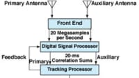
Tech Briefs
Connect Global Positioning System RF Module


Tech Briefs
Radio Signals Image Hidden and Speeding Objects
Mobility Engineering
Software-Defined Radios for Urban and Indoor Navigation


Mobility Engineering
Qualification of Multi-Channel Direction Finding Radar Receivers in The Lab
Tech Briefs
Wireless, Wearable Transmitter

Tech Briefs
Ultra-Wideband Angle-of-Arrival Tracking Systems
Mobility Engineering
Synthetic Aperture Radar for Helicopter Landing in Degraded Visual Environments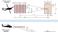

Mobility Engineering
TCU Testing at the Heart of Vehicle Connectivity

Mobility Engineering
Three Challenges to 5G’s Military Success

NASA Tech Briefs Magazine
This article first appeared in the January, 2003 issue of NASA Tech Briefs Magazine.
Read more articles from the archives here.