
To mitigate atmospheric errors caused by the troposphere, which is a limiting error source for spaceborne interferometric synthetic aperture radar (InSAR) imaging, a tropospheric correction method has been developed using data from the European Centre for Medium-Range Weather Forecasts (ECMWF) and the Global Positioning System (GPS).
After reprocessing the InSAR images using re-estimated satellite orbits, the overall rms reduction (using both tropospheric and orbit correction) spanned from 15 to 68 percent. With this tropospheric correction, low-frequency errors can be removed from InSAR images. Additionally, results show that for days with high-quality ECMWF data, the SBLM ZTD correction performs as well as the GPS ZTD correction. Finally, the tropospheric correction enabled orbit correction, and by correcting for both errors, the quality of the InSAR images increased significantly.
By correcting for the troposphere, other errors become visible. The main contributor to the remaining errors is uncertainties with determining the satellite orbit. Because the orbit error is now separated from the tropospheric error, the orbit can be corrected for more accurately.
This work was done by Frank H. Webb, Evan F. Fishbein, Angelyn W. Moore, Susan E. Owen, Eric J. Fielding, and Stephanie L. Granger of Caltech and Fredrik Björndahl and Johan Löfgren of Chalmers University of Technology for NASA’s Jet Propulsion Laboratory. NPO-46918
This Brief includes a Technical Support Package (TSP).
Tropospheric Correction for InSAR Using Interpolated ECMWF Data and GPS Zenith Total Delay
(reference NPO-46918) is currently available for download from the TSP library.
Don't have an account?
Overview
The document discusses advancements in tropospheric correction for Interferometric Synthetic Aperture Radar (InSAR) data, focusing on the integration of interpolated European Centre for Medium-Range Weather Forecasts (ECMWF) data and Global Positioning System (GPS) Zenith Total Delay (ZTD) measurements. Tropospheric effects can significantly impact the accuracy of InSAR measurements, which are crucial for applications such as land subsidence monitoring, earthquake studies, and infrastructure assessment.
The research highlights the importance of correcting for atmospheric delays caused by water vapor in the troposphere, which can introduce errors in radar signal propagation. The document presents various methodologies for achieving these corrections, including the use of ECMWF data, which provides high-resolution atmospheric information, and GPS data, which offers real-time ZTD measurements.
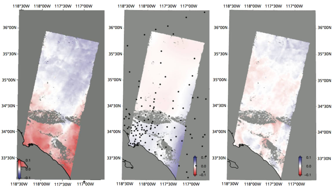
Key figures in the document illustrate the corrected InSAR results, showcasing the effectiveness of the proposed correction methods. For instance, several pairs of overpasses are analyzed, with specific dates provided for the data used in the corrections. The figures demonstrate the differences between uncorrected and corrected InSAR data, emphasizing the improvements in accuracy achieved through the proposed techniques.
The document also discusses the merging of ECMWF and GPS data to create a more robust correction map, which enhances the reliability of the tropospheric corrections applied to InSAR data. This merging process is crucial for ensuring that the corrections account for spatial and temporal variations in atmospheric conditions.
Overall, the findings suggest that integrating ECMWF and GPS data significantly improves the quality of InSAR measurements by reducing atmospheric errors. The research contributes to the ongoing efforts to enhance remote sensing technologies and their applications in various fields, including environmental monitoring, disaster response, and urban planning.
In conclusion, the document provides valuable insights into the methodologies for tropospheric correction in InSAR applications, highlighting the benefits of using a combination of ECMWF and GPS data. The advancements presented in this research have the potential to improve the accuracy of InSAR measurements, thereby enhancing their utility in scientific and practical applications.