
A proposed technique of bistatic radar altimetry would utilize information available in Global Positioning System (GPS) signals reflected from the ocean surface. The signals would be monitored by an airborne or spaceborne receiver and would be processed to determine the height, roughness, and possibly other properties of the surface. An important advantage of the proposed technique would be density and rapidity of coverage: Whereas a traditional nadirlooking radar altimeter gives the surface height at only one location below the altimeter, a receiver implementing the proposed technique could track about 10 GPS reflections simultaneously. Such dense coverage could translate to spatial and temporal resolutions greater than those previously achievable, and hence the ability to study ocean-topography features or processes beyond the reach of prior techniques. Potential applications could include monitoring of eddies and tides and tracking of fast barotropic waves.
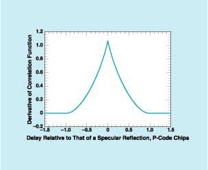
One function of particular importance for the mathematical foundation of the technique is the derivative of the correlation function (DCF) with respect to the model time delay. This function exhibits a sharp peak (see figure), the shape of which is affected in known ways by the wind speed and by surface- roughness statistics. Hence, in principle, one should be able to extract important sea-state parameters from the DCF. These parameters are, specifically, (1) the mean sea height (derived from knowledge of the location of the DCF peak relative to the model delay), (2) the ocean-surface wind (derived from the height of the DCF peak), and (3) the significant wave height (derived from the width of the DCF).
The effects of the ionosphere, troposphere, and clock errors on the accuracy of the technique have been estimated, and an overall root-mean-square value of range accuracy has been predicted as a function of sea state and antenna gain. It has been found that when one averages many measurements collected from a possible constellation of receivers, the range error would be progressively reduced as a function of space and time, yielding predicted accuracies in estimated sea height with associated spatial and temporal resolutions. Preliminary calculations indicate that sea-height accuracies of a few cm on spatial scales of 100 km from measurements averaged over four days could be achievable.
The effect of wind speed and significant wave height on the received signal has been examined by computational simulation for realistic ranges of wind speeds and wave heights. The bistatic geometry has been found to make the sea-height measurements less sensitive to wave heights than are the sea-height measurements of conventional nadir- viewing geometry. The electromagnetic bias of the scattered waveform has also been found to be reduced. The range accuracy versus receiving-antenna gain and scattering direction were also examined; it was found that at low elevation angles, both the scattering cross section and the coherence time are greater than those at nadir, resulting in a potential decrease of the range error for a fixed antenna gain. Finally, the possibility of tracking the phase of the GPS signal at small elevation angles and the resulting improvement in the range-measurement accuracy has also been examined theoretically.
This work was done by Cinzia Zuffada, George Hajj, and J. Brooks Thomas of Caltech for NASA’s Jet Propulsion Laboratory. For further information, access the Technical Support Package (TSP) free on-line at www.nasatech.com/tsp under the Information Sciences category. NPO-20943