The Foldable Drone: a Morphing Quadrotor that can Squeeze and Fly
Davide Falanga, Kevin Kleber, Stefano Mintchev, Dario Floreano, and Davide Scaramuzza
University of Zurich,
Switzerland
Recent advances in state estimation, perception, and navigation algorithms have significantly contributed to the use of quadrotors for inspection, mapping, and aerial imaging. Inspecting a damaged building after an earthquake or during a fire is the kind of job human rescuers would like drones to do. A flying robot could look for people trapped inside and guide the rescue team towards them. But the drone would often have to enter the building through a crack in a wall, a partially open window, or through bars — something the typical size of a drone does not allow.

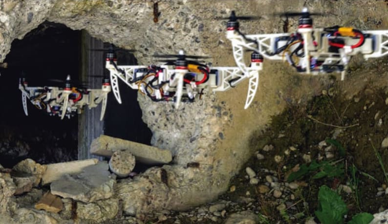
A novel, simpler, yet effective morphing design for quadrotors consists of a frame with four independently rotating arms that fold around the main frame. To guarantee stable flight at all times, an optimal control strategy adapts on the fly to the drone morphology.
The team designed a quadrotor with four propellers that rotate independently, mounted on mobile arms that can fold around the main frame using servomotors. A control system adapts in real time to any new position of the arms, adjusting the thrust of the propellers as the center of gravity shifts.
The standard configuration is X-shaped, with the four arms stretched out and the propellers at the widest possible distance from each other. When faced with a narrow passage, the drone can switch to an “H” shape, with all arms lined up along one axis or to an “O” shape, with all arms folded in as close as possible. A “T” shape can be used to bring the onboard camera mounted on the central frame close to objects that the drone needs to inspect.
The versatility of the design was demonstrated in different tasks such as negotiating narrow gaps, close inspection of vertical surfaces, and object grasping and transportation. The experiments were performed on actual, fully autonomous quadrotors, relying solely on onboard visual-inertial sensors and computing. No external motion tracking systems and computers were used.
For more information, visit here .
HONORABLE MENTIONS
Exponential Engine
Frank Ardezzone,
Probe-Rite Corp.,
Santa Clara, CA USA

The Exponential Engine is a modification to current piston and valve engines that will generate 4x the power for the same displacement current as Otto cycle engines. The concept replaces crankshafts with a patent-pending cam-crank, permitting two power strokes per drive shaft revolution; thus, generating 4x the power for the same displacement. In case of an engine-out condition, one engine is still operable, thereby protecting lives in passenger aircraft and equipment in surveillance and drone applications.
For more information, visit here
Augmented Reality Monitoring System for Aircraft Wiring Maintenance
Daryian Rhysing, Evaguel Rhysing, and Donald DeVito,
United Aircraft Technologies,
Dover, DE USA

A smart aircraft Inter-Connecting Clamp (ICC) solution with an Augmented Reality Monitoring System for aircraft wiring improves fuel economy, decreases repetitive strain injuries among workers, simplifies maintenance through 3D fault location and visualization, and reduces the environmental impact of CO2 emissions. An embedded RFID chip can read the voltage and amperage flow in a bundle of cables. When used with a 3D camera, it visualizes hidden faults in wire bundles.
For more information, visit here
Impregnated Epoxy Actuators Paired with a Sparse-array Sensor Grid for Strain Detection of Composite Barely Visible Damage
Zhaoyuan Leong, Nicola Morley, and Pratik Desai,
University of Sheffield,
United Kingdom

Carbon fiber reinforced polymer composites (CFRCs) are prone to damages such as fiber breakage, debonding, and delamination; as a result, they require frequent visual inspections. A two-part solution homogeneously embeds dispersions of magnetostrictive microparticles within a suitably thin, flexible matrix as an adhesive patch, which is then coupled to an adhesive sparse-array sensor grid that can be used to determine damage position and provide offline measurement ability.
For more information, visit here
Controlled Flight into Terrain (CFIT) Prevention
Charles Wood,
Orange, CA USA

This device uses GPS and a terrain/ obstacle database to create a predicted flight path. When the predicted flight path detects an approaching CFIT threat, the device gives the pilot an audible warning and a visual display. The pilot gets a 3D visual picture of where the predicted flight path will hit the terrain/obstacle. By maneuvering the airplane, the pilot can alter the predicted flight path away from the terrain/obstacle. When the predicted flight path no longer detects a CFIT threat, the system returns to the passive mode.
For more information, visit here .
See the rest of this year's winners:
- GRAND PRIZE WINNER
- MEDICAL CATEGORY WINNER
- ELECTRONICS/SENSORS/IOT CATEGORY WINNER
- MANUFACTURING/ROBOTICS/AUTOMATION CATEGORY WINNER
- AUTOMOTIVE/TRANSPORTATION CATEGORY WINNER
- CONSUMER PRODUCTS CATEGORY WINNER
- SUSTAINABLE TECHNOLOGIES CATEGORY WINNER

