
NASA’s newest, more technologically advanced radiometer instrument detects microwave energy from space, allowing scientists to study how much water is in the Earth's soil.
Soil moisture is an important measurement for weather forecasting, drought and flood predictions, and agriculture. All types of soil emit microwave radiation, but the amount of water changes how much of the energy is emitted. The drier the soil, the more microwave energy; the wetter the soil, the less energy. Radiometers measure the radiation, and scientists use the data to calculate water content.
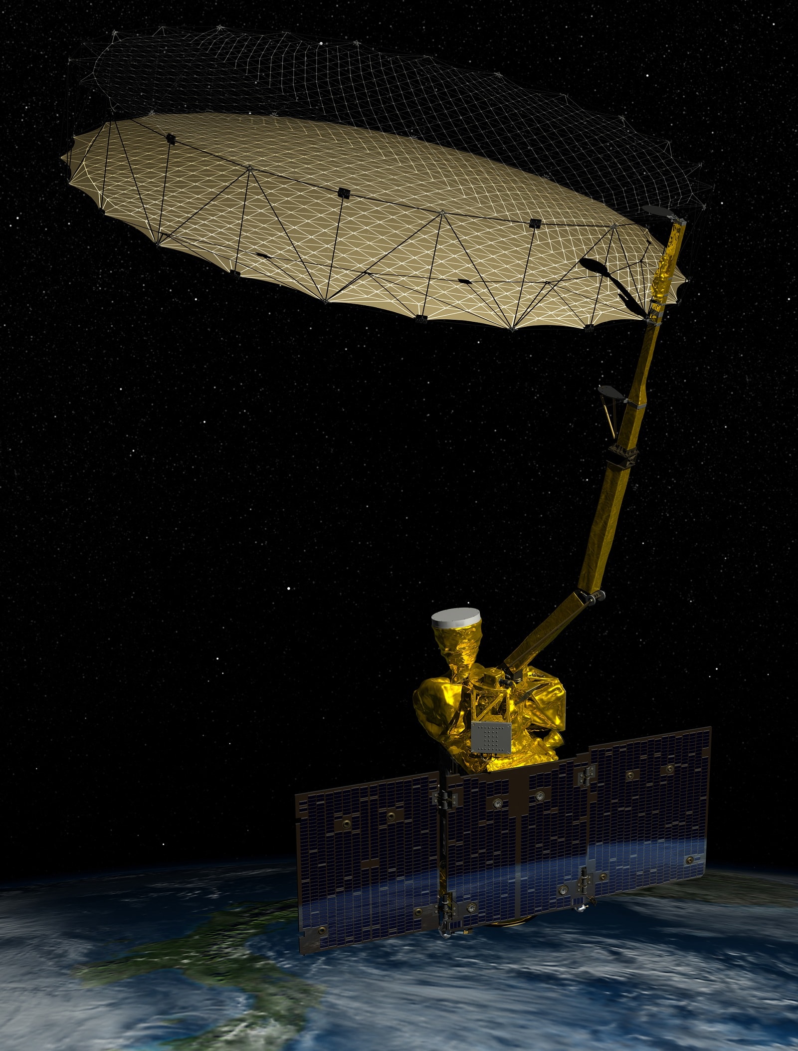
The new radiometer launches into orbit aboard the Soil Moisture Active Passive (SMAP) satellite. SMAP carries two instruments to measure how much water is in the soil. In addition to the radiometer, which detects naturally emitted energy, a microwave radar will send a signal to the ground that will bounce back to the satellite with information after it encounters and interacts with the soil. To collect signals from the surface for both the radiometer and radar, SMAP has a 20-foot-wide mesh antenna that rotates 14 times per minute – the largest such spinning antenna in space. A receiver then interprets both sets of signals.
The two instruments complement each other: the radiometer provides an accurate measurement of a large block of land, while the radar provides finer detail of the soil moisture in smaller parcels.
"Combine the two together, use the best of both, and you come up with a pretty accurate soil moisture product at a spatial resolution of 6 miles," said Peggy O’Neill, SMAP deputy project scientist.
Also: Learn about the Soil Moisture Active Passive (SMAP) mission.
Transcript
00:00:00 Astronomers use radio telescopes to study distant stars and galaxies. They use a band of microwave frequencies reserved for scientists studying the heavens and the earth. By international treaty there are no transmissions allowed in this band, so I can't set up a television transmitter, say, and operate here. It's dedicated, set aside, for what we call "passive use," or in this case the microwave radiometer listening to the natural signals from the Earth. NASA is using this band to study the water content of soil for its Earth-observing SMAP mission, which stands for "Soil Moisture Active Passive."
00:00:41 The "active passive" part really refers to the instrument, so the active portion is a microwave radar, and the passive portion is a microwave radiometer that we built here at Goddard Space Flight Center. Every molecule naturally gives off or absrobs microwave energy to maintain a balance with its surroundings. The amount given off by the soil depend on its temperature and its water content. The molecules in the soil with the water, they're bouncing around off of each other and emitting microwaves. The dry soil lets out a lot of these microwaves and the wetter soil lets out fewer of these microwaves. The challenge is that the neighboring bands
00:01:21 have radars and communications systems and those transmissions can unintentionally leak into our spectrum. So we had to develop dedicated technology for SMAP to try to separate out the natural signals from the earth and the human-made signals that we don't want. The signals that we want the SMAP radiometer to listen to, they vary slowly in time. they are very broadband. And in fact what they are is, it sounds like - if you were to hook up a radio receiver and listen to it yourself, it would sound like noise, it would sound like static.
00:02:01 So we look for signals that don't look like static and that's what we want to throw away and keep the static for ourselves. So the team here at Goddard developed specialized hardare and software. It separates out the signals that the radiometer receives in time and frequency and for every spot on the ground, looks for outliers and if it sees those, it just removes them from the measurement. Throws away the bad, keeps the good, and produces the data to give us good measurements of soil moisture here today to allow us to improve weather forecasting, drought and flood predictions, and forecast crop yields better.
00:02:41