
Originating Technology/NASA Contribution
While many air travelers are accustomed to rules against electronic devices during takeoff and landing, they might not be aware that these devices are banned because they can cause electromagnetic interference (EMI) with navigation equipment. Because similar problems can occur near launch sites for space missions, NASA began investigating technologies for tracking this interference in order to protect sensitive mission instrumentation. This electronic encroachment is partly due to a myriad of modern communication devices in the marketplace, but unfortunately could also be due to intentional and malicious transmissions. Uninterrupted communication between range activities, mission control, and the flight deck is critical to human safety and mission security, so NASA worked with a company that develops custom communication systems to design a system for locating sources of radio interference.
Partnership

In 2005, Kennedy Space Center awarded a Phase I Small Business Innovation Research (SBIR) contract to Soneticom Inc., in West Melbourne, Florida. Recognizing the inability of existing tools to locate radio interference, the company developed a network of sensors to locate EMI sources, controlled by algorithms and receivers the company also developed under the contract. With a follow-on Phase II agreement in 2006, the company continued to develop the algorithms and receivers that were then integrated with software for data collection and analysis in the company’s Lynx Location System (LLS).
In 2009, Soneticom began collaborating with the Federal Aviation Administration (FAA) to install and test the LLS at its field test center in New Jersey in preparation for deploying the LLS at commercial airports. The FAA reports that each year there are many cases of inadvertent interference and intentional disruptions of cockpit to tower communications at major airports. With a Phase III SBIR contract, Soneticom also plans to begin testing a new field strength mapping feature for the LLS in the near future.
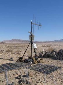
Product Outcome
Soneticom’s LLS is an EMI precision geolocation system with two major components: the Control Station, a software package that runs on a laptop; and multiple compact, rugged, unattended processing sensors, which rely on the NASA-funded receiver components. The software collects data from each sensor in order to compute the location of the interfering emitter. The sensors can be mounted with existing infrastructure for power and wireless communications, or Soneticom can provide an independent power system on a tripod with battery or solar power options.
Before locating interference, the LLS establishes a baseline by capturing and averaging radio frequency (RF) readings. Ron Cobb, Soneticom’s vice president of advanced communications systems, explains that the company deploys three or more sensors to an area, whereupon the system confirms receipt of a signal from the software. After the Control Station confirms communication from the sensors, it compares this baseline with real-time data to locate interference in a process called radio interferometry (RI), which uses NASA-developed algorithms to cross-correlate a fringe pattern produced when multiple antennas are tuned to a specific frequency.
Using another algorithm called time difference of arrival (TDOA), which was also developed under the NASA SBIR, Cobb says the system locates disruptive signals down to small footprints, or “dots on a map.” The system then begins to differentiate between harmless radio traffic, such as from a recreational boater, and an intentional threat. The LLS begins alerting users to unusual activity on the RF spectrum, including changes in radiated power, signal strength, and EMI levels.
Dwayne Free, senior systems engineer at Soneticom, says that one of the applications of the LLS system will be keeping runway (and launch) operations free from radio frequency interference. Because uninterrupted communication between crews in the tower (or mission control) and in the cockpit is critical to safety, the threat mitigation system could secure communications before flight, while a vehicle waits for takeoff.
NASA and the FAA are not the only government agencies interested in locating (and preventing) security threats from radio interference. Other agencies and security firms that need to monitor anomalous RF emissions have purchased Soneticom’s LLS. The company has had a number of sales to private customers, all interested in preventing electronic encroachment, and although some frequencies differ between industries and organizations, the technology and processes are the same. Soneticom hopes to add the U.S. Air Force to its list of customers, seeing an easy transfer of the LLS to the Air Force’s launch needs at Cape Canaveral and Vandenberg Air Force Base. Another potential customer is the Federal Communications Commission, which could use the LLS to enforce radio frequency licenses.
Plans for the LLS and Soneticom’s related RI/TDOA services include adapting the technology into smaller tracking devices, both for objects and for people, in an approach called cooperative tracking. An RI/TDOA personnel tracking device could track individuals in high-security or high-risk locations; astronauts, military personnel, firefighters, miners, and other individuals at risk could wear small beacons that would track their locations for their safety, and could also identify individuals without proper access. Security personnel and military forces approaching an area of operations could use RF tracking to secure an area from physical intrusion, not just radio interference. The system could also monitor and secure radio traffic during demolition explosions at construction sites. In 2009, Soneticom hopes to complete an enhanced mapping product, the EMI Image, which will be compatible with the LLS and has been developed with NASA SBIR funding.
Parsippany, New Jersey’s DRS Technologies, a supplier of integrated products to military forces and intelligence agencies, announced with Soneticom in May that DRS has agreed to acquire the Florida company.