
Joe Spruce’s last name is a fitting one: Spruce is a research scientist at NASA’s Stennis Space Center working with the US Department of Agriculture Forest Service to monitor forests and other vegetation across the country using NASA satellite data.
Issues affecting forests can have a tremendous impact on the health of their associated ecosystems, watersheds, and forest-dependent communities. The USDA Forest Service’s Asheville, NC-based Eastern Forest Environmental Threat Assessment Center and the Prineville, OR-based Western Wildlands Environmental Threat Assessment Center partnered with NASA Stennis Space Center, the US Geological Service (USGS) Earth Resource Observation System (EROS), and the Department of Energy’s (DOE) Oak Ridge National Laboratory (ORNL) to create a near-real-time early warning system to identify, characterize, and track regional disturbances from potential forest threats.
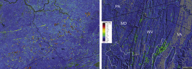
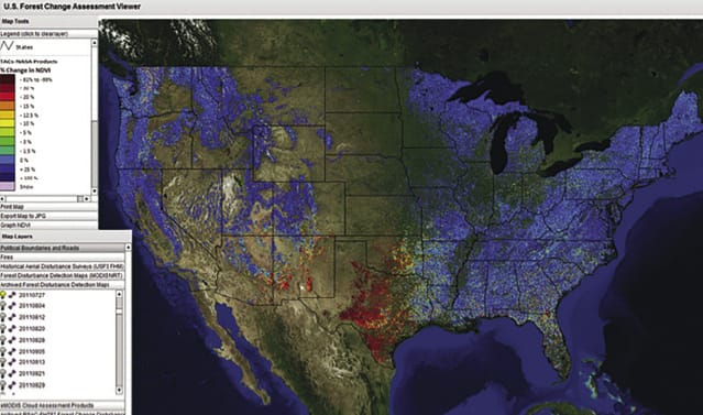
The result was ForWarn, a national forest monitoring system that utilizes the reflectance data obtained from MODIS to compute forest health indicator products. ForWarn’s forest change assessment products have been used for a variety of applications from science to resource management to communication, education, and outreach.
ForWarn is used by federal and state forest and natural resource managers across the country. Remotely sensed observations of vegetation life can contribute to a much broader-scale understanding of vegetation disturbances (including abiotic and biotic) not available from ground-based perspectives.
Abiotic disturbances are being detected and tracked, such as damage from hurricanes, drought in Texas and neighboring states, hail in North Carolina, wildfires in Front Range forests of Colorado, and wind, river flooding ice, and frost. Biotic disturbances such as forest defoliation and mortality typically caused by multiple insect pests are also being observed.
The tool complements and helps focus existing forest monitoring efforts at more local scales, which will likely result in time and cost savings. In the future, ForWarn will be capable of automatically recognizing disturbances. ForWarn already examines all terrestrial vegetation of the contiguous United States, but its FCAV currently only shows forest change products. Based on recent experiments, it could have value in tracking agriculture and range vegetation disturbances. ForWarn could be used for detecting disturbances in these non-forested landscapes as well.
Visit http://spinoff.nasa.gov/Spinoff2013/ee_4.html for the full story.