
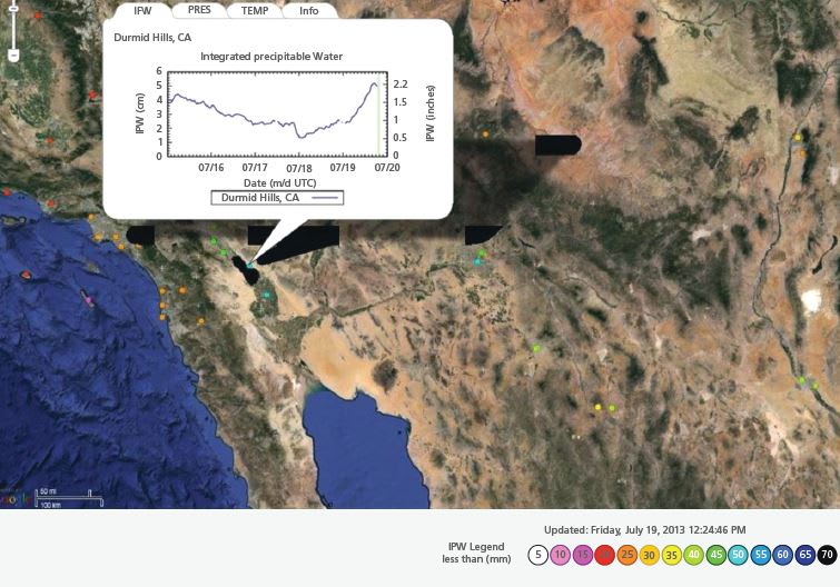
Global Positioning System (GPS) meteorology provides enhanced density, low-latency (30-min resolution), integrated precipitable water (IPW) estimates to NOAA NWS (National Oceanic and Atmospheric Administration National Weather Service) Weather Forecast Offices (WFOs) to provide improved model and satellite data verification capability and more accurate forecasts of extreme weather such as flooding. An early activity of this project was to increase the number of stations contributing to the NOAA Earth System Research Laboratory (ESRL) GPS meteorology observing network in Southern California by about 27 stations. Following this, the Los Angeles/Oxnard and San Diego WFOs began using the enhanced GPS-based IPW measurements provided by ESRL in the 2012 and 2013 monsoon seasons. Forecasters found GPS IPW to be an effective tool in evaluating model performance, and in monitoring monsoon development between weather model runs for improved flood forecasting.
This work was done by Angelyn W. Moore of Caltech; Seth I. Gutman and Kirk Holub of NOAA Earth System Research Laboratory; Yehuda Bock of UC San Diego’s Scripps Institution of Oceanography; and David Danielson, Jayme Laber, and Ivory Small of NOAA National Weather Service. NPO-48881
This Brief includes a Technical Support Package (TSP).
GPS Estimates of Integrated Precipitable Water Aid Weather Forecasters
(reference NPO-48881) is currently available for download from the TSP library.
Don't have an account?
Overview
The document discusses the use of GPS estimates of Integrated Precipitable Water (IPW) to enhance weather forecasting, particularly during the monsoon season in Southern California. Authored by a team from NASA's Jet Propulsion Laboratory, NOAA, and U.C. San Diego, it emphasizes the challenges faced by forecasters due to the nonlinear nature of the atmosphere and the limitations of existing weather models. These models often lack precision and can disagree on forecasts, making real-time data crucial for accurate predictions.
The North American Monsoon is highlighted as a significant weather phenomenon that brings moist air from various sources, including the Gulf of California and the Eastern Tropical Pacific. This influx of moisture can lead to severe thunderstorms, but forecasting these events is complicated by the sparse meteorological observations in Mexico and the Pacific, as well as the wide spacing of radiosonde sites in nearby cities like San Diego, Tucson, and Phoenix. As a result, forecasters often struggle to pinpoint the boundary between moist and dry air aloft, which is essential for predicting monsoon thunderstorms accurately.
To address these challenges, the document outlines future initiatives, including the installation of a 27-station network equipped with meteorological sensors and a geodetic module. This network aims to facilitate onsite calculations and transmission of Integrated Water Vapor (IWV) data, improving the availability and accuracy of real-time information for forecasters. The document also mentions the development of a prototype accelerometer package and a prototype meteorological package to further enhance forecasting capabilities.
The use of GPS technology for meteorological purposes is underscored, with references to previous research that has successfully utilized GPS for remote sensing of atmospheric water vapor. The document concludes by acknowledging the collaborative efforts of various institutions in advancing the use of GPS data for weather forecasting, which is expected to significantly improve the ability to issue timely warnings for potentially dangerous weather events.
Overall, the document serves as a technical support package that highlights the importance of integrating advanced technology into meteorological practices to enhance the accuracy and reliability of weather forecasts, particularly in regions prone to extreme weather events like Southern California.