
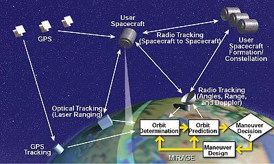
The Multiple Interferometric Ranging Analysis using GPS Ensemble (MIRAGE) computer program processes spacecraft-tracking data to determine orbits of single satellites, or of multiple satellites with intersatellite tracking, to within position errors as small as a few centimeters (see figure). MIRAGE also targets spacecraft maneuvers (changes of velocity) to precision higher than that achievable by current spacecraft hardware. Tracking data that MIRAGE can utilize include Global Positioning System (GPS) pseudorange and phase, data from general range and Doppler measurements, angles, data from optical measurements, and data from very-long-baseline interferometry (VLBI). The modular program structure enables addition of other tracking data types for specific user spacecraft.
MIRAGE implements a variety of geometrical and dynamical models that the user can control. A pseudo-epoch-state filter in MIRAGE smooths over data arcs selectable by the user, yielding robust solutions in the presence of bad tracking data and modeling errors. Operation is simplified through a system of interdependent and automated Unix and Perl scripts or through interactive X-Window menu-driven software wrappers. MIRAGE could be particularly useful for navigating multiple satellites to maintain them in a constellation for global telecommunications.
This program was written by Bobby G. Williams, Peter J. Wolff, Rick F. Sunseri, Theodore R. Drain, James B. Collier, Tseng-Chan Wang, and Joseph R. Guinn of Caltech for NASA's Jet Propulsion Laboratory. NPO-20287
This Brief includes a Technical Support Package (TSP).
Program performs high-precision spacecraft-constellation navigation
(reference NPO20287) is currently available for download from the TSP library.
Don't have an account?
Overview
The document outlines the development and operational capabilities of the MIRAGE software, a system designed for high-precision spacecraft orbit determination. Developed by the Jet Propulsion Laboratory (JPL) under a NASA contract, MIRAGE processes various tracking data types, including GPS and optical measurements, to achieve sub-decimeter accuracy in orbit determination.
The document details the automated processes involved in data collection, editing, and orbit determination. Automated refomatting, cycle slip editing, and calibration of GPS data are performed to produce accurate orbit determination observables. The ground GPS receiver observations are made available approximately 36 hours after data collection, with both carrier phase and pseudorange measurements provided in 30-second samples. The system is designed to handle data from multiple ground sites, ensuring redundancy and reliability in orbit determination.
MIRAGE operates through a three-step process: trajectory propagation, observation processing, and fitting and smoothing. This iterative approach continues until convergence of state solutions and observation residuals is achieved. The system is capable of processing data from a network of ground stations, allowing for internal consistency checks and the filling of data gaps during outages.
The document also discusses the operational requirements for the GPS Data Processing Facility (GDPF), which includes personnel, computer resources, and time needed to produce daily solutions. The automation of the processing workflow minimizes the need for human intervention, reducing the potential for user input errors. The GDPF team operates on a five-day work schedule, with provisions for backup personnel and hardware maintenance.
In conclusion, the MIRAGE software has demonstrated its effectiveness in orbit determination for various missions, including the TOPEX/Poseidon satellite. Comparisons with other precision orbit solutions indicate that MIRAGE meets and exceeds original performance requirements, providing results comparable to other geodetic quality software. The document highlights the significant advancements in automated orbit determination and the contributions of the JPL team in enhancing satellite tracking capabilities for scientific and commercial applications.