42
-1
1530
30
Briefs: Software
Space Physics Data Facility Web Services
The Space Physics Data Facility (SPDF) Web services provides a distributed programming interface to a portion of the SPDF software. (A general description of Web services is available at http://www.w3.org/ and in many current software-engineering texts and articles focused on distributed programming.) The...
Briefs: Software
Parallel Adaptive Mesh Refinement Library
Parallel Adaptive Mesh Refinement Library (PARAMESH) is a package of Fortran 90 subroutines designed to provide a computer programmer with an easy route to extension of (1) a previously written serial code that uses a logically Cartesian structured mesh into (2) a parallel code with adaptive mesh refinement...
Briefs: Software
Estimating Effects of Multipath Propagation on GPS Signals
Multipath Simulator Taking into Account Reflection and Diffraction (MUSTARD) is a computer program that simulates effects of multipath propagation on received Global Positioning System (GPS) signals. MUSTARD is a very efficient means of estimating multipath-induced position and phase errors...
Briefs: Electronics & Computers
Central-Monitor Software Module
One of the software modules of the emergency-vehicle traffic-light-preemption system of the two preceding articles performs numerous functions for the central monitoring subsystem. This module monitors the states of all units (vehicle transponders and intersection controllers): It provides real-time access to the...
Briefs: Software
Intersection-Controller Software Module
An important part of the emergencyvehicle traffic-light-preemption system summarized in the preceding article is a software module executed by a microcontroller in each intersection controller. This module monitors the broadcasts from all nearby participating emergency vehicles and intersections. It gathers...
Briefs: Medical
Traffic-Light-Preemption Vehicle-Transponder Software Module
A prototype wireless data-communication and control system automatically modifies the switching of traffic lights to give priority to emergency vehicles. The system, which was reported in several NASA Tech Briefs articles at earlier stages of development, includes a transponder on each...
Briefs: Photonics/Optics
An advanced computer code is undergoing development for numerically simulating laser cooling and trapping of large numbers of atoms. The code is expected to be useful in...
Briefs: Software
Tools for Designing and Analyzing Structures
Structural Design and Analysis Toolset is a collection of approximately 26 Microsoft Excel spreadsheet programs, each of which performs calculations within a different subdiscipline of structural design and analysis.
Briefs: Software
Interactive Display of Scenes With Annotations
ThreeDView was developed primarily as a component of the Science Activity Planner (SAP) software, wherein it is to be used to display annotated images of terrain acquired by exploratory robots on Mars and possibly other remote planets. The images can be generated from sets of multiple-texture image...
Briefs: Software
Solving Common Mathematical Problems
Mathematical Solutions Toolset is a collection of five software programs that rapidly solve some common mathematical problems.
Briefs: Software
Tools for Basic Statistical Analysis
Statistical Analysis Toolset is a collection of eight Microsoft Excel spreadsheet programs, each of which performs calculations pertaining to an aspect of statistical analysis.
Briefs: Software
Software for Automated Testing of Mission-Control Displays
MCC Display Cert Tool is a set of software tools for automated testing of computer terminal displays in spacecraft mission-control centers, including those of the space shuttle and the International Space Station. This software makes it possible to perform tests that are more thorough, take...
Briefs: Software
WinPlot
WinPlot is a powerful desktop graphical analysis tool that allows the user to generate displays of unrestrictive amounts of data. It is designed to operate on a Windows 98/NT/2000 based desktop platform. WinPlot was developed to fulfill the need for fast and easily managed graphical displays of NASA test articles and facilities with extreme...
Briefs: Software
Software for Autonomous Spacecraft Maneuvers
The AutoCon computer programs facilitate and accelerate the planning and execution of orbital control maneuvers of spacecraft while analyzing and resolving mission constraints. AutoCon-F is executed aboard spacecraft, enabling the spacecraft to plan and execute maneuvers autonomously; AutoCon-G is...
Briefs: Software
Software Assists in Responding to Anomalous Conditions
(FIDO) is a computer program that reduces the need for a large and costly team of engineers and/or technicians to monitor the state of a spacecraft and associated ground systems and respond to anomalies. FIDO includes artificial-intelligence components that imitate the reasoning of human...
Briefs: Software
Program Analyzes Radar Altimeter Data
A computer program has been written to perform several analyses of radar altimeter data. The program was designed to improve on previous methods of analysis of altimeter engineering data by (1) facilitating and accelerating the analysis of large amounts of data in a more direct manner and (2) improving the...
Briefs: Software
Format for Interchange and Display of 3D Terrain Data
Visible Scalable Terrain (ViSTa) is a software format for production, interchange, and display of three-dimensional (3D) terrain data acquired by stereoscopic cameras of robotic vision systems. ViSTa is designed to support scalability of data, accuracy of displayed terrain images, and optimal...
Briefs: Software
Controlling Distributed Planning
A system of software implements an extended version of an approach, denoted shared activity coordination (SHAC), to the interleaving of planning and the exchange of plan information among organizations devoted to different missions that normally communicate infrequently except that they need to collaborate on joint...
Briefs: Software
Activity-Centric Approach to Distributed Programming
The first phase of an effort to develop a NASA version of the Cybele software system has been completed. To give meaning to even a highly abbreviated summary of the modifications to be embodied in the NASA version, it is necessary to present the following background information on Cybele:
Briefs: Software
Initial Processing of Infrared Spectral Data
The Atmospheric Infrared Spectrometer (AIRS) Science Processing System is a collection of computer programs, denoted product generation executives (PGEs), for processing the readings of the AIRS suite of infrared and microwave instruments orbiting the Earth aboard NASA 's Aqua spacecraft. Following from...
Briefs: Software
Verifying Diagnostic Software
Livingstone PathFinder (LPF) is a simulation-based computer program for verifying autonomous diagnostic software. LPF is designed especially to be applied to NASA's Livingstone computer program, which implements a qualitative-model-based algorithm that diagnoses faults in a complex automated system (e.g.,an exploratory...
Briefs: Software
Neuropsychological Testing of Astronauts
The Spaceflight Cognitive Assessment Tool for Windows (WinSCAT) is a computer program that administers a battery of five timed neuro-cognitive tests.WinSCAT was developed to give astronauts an objective and automated means of assessing their cognitive functioning during space flight, as compared with their...
Briefs: Software
Preparing and Analyzing Iced Airfoils
SmaggIce version 1.2 is a computer program for preparing and analyzing iced airfoils.It includes interactive tools for
measuring ice-shape characteristics,
controlled smoothing of ice shapes,
curve discretization,
generation of artificial ice shapes,and
detection and correction of input errors.
Briefs: Software
Collaborative Planning of Robotic Exploration
The Science Activity Planner (SAP) software system includes an uplink-planning component, which enables collaborative planning of activities to be undertaken by an exploratory robot on a remote planet or on Earth. Included in the uplink-planning component is the SAP-Uplink Browser, which enables users...
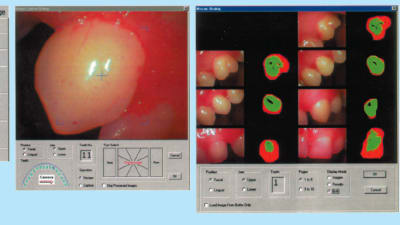
Briefs: Imaging
A new software equipped with novel image processing algorithms and graphical-user-interface (GUI) tools has been designed for automated analysis and processing of...
Briefs: Software
Prioritizing Scientific Data for Transmission
A software system has been developed for prioritizing newly acquired geological data onboard a planetary rover. The system has been designed to enable efficient use of limited communication resources by transmitting the data likely to have the most scientific value. This software operates onboard a...
Briefs: Software
Open-Source Software for Modeling of Nanoelectronic Devices
The Nanoelectronic Modeling 3-D (NEMO 3-D) computer program has been upgraded to open-source status through elimination of license-restricted components. The present version functions equivalently to the version reported in “Software for Numerical Modeling of Nanoelectronic Devices”...
Briefs: Software
Software for Generating Strip Maps From SAR Data
Jurassicprok is a computer program that generates strip-map digital elevation models and other data products from raw data acquired by an airborne synthetic-aperture radar (SAR) system. This software can process data from a variety of airborne SAR systems but is designed especially for the GeoSAR...
Briefs: Software
Calibration Software for Use With Jurassicprok
The Jurassicprok Interferometric Calibration Software (also called “Calibration Processor” or simply “CP”) estimates the calibration parameters of an airborne synthetic- aperture-radar (SAR) system, the raw measurement data of which are processed by the Jurassicprok software described in the...
Top Stories
 Blog: Power
My Opinion: We Need More Power Soon — Is Nuclear the Answer?
 Blog: AR/AI
Aerial Microrobots That Can Match a Bumblebee's Speed
 News: Energy
 Blog: Electronics & Computers
Turning Edible Fungi into Organic Memristors
 Blog: Robotics, Automation & Control
Microscopic Swimming Machines that Can Sense, Respond to Surroundings
 INSIDER: Sensors/Data Acquisition
Webcasts
 Upcoming Webinars: Power
Hydrogen Engines Are Heating Up for Heavy Duty
 Upcoming Webinars: Electronics & Computers
Advantages of Smart Power Distribution Unit Design for Automotive...
 Upcoming Webinars: Transportation
Quiet, Please: NVH Improvement Opportunities in the Early Design...
 Upcoming Webinars: Sensors/Data Acquisition
From Spreadsheets to Insights: Fast Data Analysis Without Complex...
 Upcoming Webinars: Energy
Battery Abuse Testing: Pushing to Failure