42
-1
810
30
Briefs: Information Technology
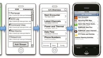
FERMI/GLAST Integrated Trending and Plotting System Release 5.0
An Integrated Trending and Plotting System (ITPS) is a trending, analysis, and plotting system used by space missions to determine performance and status of spacecraft and its instruments. ITPS supports several NASA mission operational control centers providing engineers, ground...
Briefs: Information Technology
Scalable Integrated Multi-Mission Support System Simulator Release 3.0
The Scalable Integrated Multi-mission Support System (SIMSS) is a tool that performs a variety of test activities related to spacecraft simulations and ground segment checks.
Briefs: Software
A successful policy negotiation scheme for Policy-Based Management (PBM) has been implemented. Policy negotiation is the process of determining the “best” communication...

Briefs: Information Technology
SE-FIT
The mathematical theory of capillary surfaces has developed steadily over the centuries, but it was not until the last few decades that new technologies have put a more urgent demand on a substantially more qualitative and quantitative understanding of phenomena relating to capillarity in general. So far, the new theory development...
Briefs: Information Technology
WMS Server 2.0
This software is a simple, yet flexible server of raster map products, compliant with the OGC WMS 1.1.1 protocol. The server is a full implementation of the OGC WMS 1.1.1 as a fastCGI client and using GDAL for data access. The server can operate in a proxy mode, where all or part of the WMS requests are done on a back server.
Briefs: Software
NASA is interested in designing a spacecraft capable of visiting a near- Earth object (NEO), performing experiments, and then returning safely. Certain...
Briefs: Software
At the time of this reporting, there are 2,589 rich mobile devices used at JPL, including 1,550 iPhones and 968 Blackberrys. Considering a total JPL population of 5,961 employees, mobile applications have a total...
Briefs: Software
Ascent/Descent Software
The Ascent/Descent Software Suite has been used to support a variety of NASA Shuttle Program mission planning and analysis activities, such as range safety, on the Integrated Planning System (IPS) platform. The Ascent/Descent Software Suite, containing Ascent Flight Design (ASC)/Descent Flight Design (DESC) Configuration...
Briefs: Software
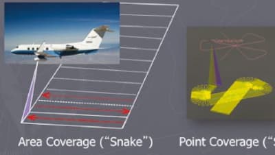
I-FORCAST (Instrument – Field of Regard Coverage Analysis and Simulation Tool) is a flight planning tool specifically designed for quickly verifying the feasibility and estimating the cost of airborne...
Briefs: Information Technology
Leveraging Cloud Computing to Improve Storage Durability, Availability, and Cost for MER Maestro
The Maestro for MER (Mars Exploration Rover) software is the premiere operation and activity planning software for the Mars rovers, and it is required to deliver all of the processed image products to scientists on demand. These data span multiple...
Briefs: Software
If carmakers could reduce the number, size, and weight of the components in there, better fuel economy would result. A case in point is the design and...

Briefs: Software
POSTMAN: Point of Sail Tacking for Maritime Autonomous Navigation
Waves apply significant forces to small boats, in particular when such vessels are moving at a high speed in severe sea conditions. In addition, small high-speed boats run the risk of diving with the bow into the next wave crest during operations in the wavelengths and wave speeds...
Briefs: Imaging
Aerosol and Surface Parameter Retrievals for a Multi-Angle, Multiband Spectrometer
This software retrieves the surface and atmosphere parameters of multi-angle, multiband spectra. The synthetic spectra are generated by applying the modified Rahman-Pinty-Verstraete Bidirectional Reflectance Distribution Function (BRDF) model, and a single-scattering...
Briefs: Data Acquisition
LogScope
LogScope is a software package for analyzing log files. The intended use is for offline post-processing of such logs, after the execution of the system under test. LogScope can, however, in principle, also be used to monitor systems online during their execution. Logs are checked against requirements formulated as monitors expressed in a...
Briefs: Software
TraceContract
TraceContract is an API (Application Programming Interface) for trace analysis. A trace is a sequence of events, and can, for example, be generated by a running program, instrumented appropriately to generate events. An event can be any data object. An example of a trace is a log file containing events that a programmer has found...
Briefs: Aerospace
AIRS Maps From Space Processing Software
This software package processes Atmospheric Infrared Sounder (AIRS) Level 2 swath standard product geophysical parameters, and generates global, colorized, annotated maps. It automatically generates daily and multi-day averaged colorized and annotated maps of various AIRS Level 2 swath geophysical...
Briefs: Software
Motion-Capture-Enabled Software for Gestural Control of 3D Models
Current state-of-the-art systems use general-purpose input devices such as a keyboard, mouse, or joystick that map to tasks in unintuitive ways. This software enables a person to control intuitively the position, size, and orientation of synthetic objects in a 3D virtual environment....
Briefs: Software
Orbit Software Suite
Orbit Software Suite is used to support a variety of NASA/DM (Dependable Multiprocessor) mission planning and analysis activities on the IPS (Intrusion Prevention System) platform. The suite of Orbit software tools (Orbit Design and Orbit Dynamics) resides on IPS/Linux workstations, and is used to perform mission design and...
Briefs: Software
CoNNeCT Baseband Processor Module Boot Code SoftWare (BCSW)
This software provides essential startup and initialization routines for the CoNNeCT baseband processor module (BPM) hardware upon power-up. A command and data handling (C&DH) interface is provided via 1553 and diagnostic serial interfaces to invoke operational, reconfiguration, and...
Briefs: Software
Trajectory Software With Upper Atmosphere Model
The Trajectory Software Applications 6.0 for the Dec Alpha platform has an implementation of the Jacchia-Lineberry Upper Atmosphere Density Model used in the Mission Control Center for International Space Station support. Previous trajectory software required an upper atmosphere to support atmosphere...
Briefs: Software
ALSSAT Version 6.0
Advanced Life Support Sizing Analysis Tool (ALSSAT) at the time of this reporting has been updated to version 6.0. A previous version was described in “Tool for Sizing Analysis of the Advanced Life Support System” (MSC- 23506), NASA Tech Briefs, Vol. 29, No. 12 (December 2005), page 43. To recapitulate: ALSSAT is a computer...
Briefs: Software
iGlobe Interactive Visualization and Analysis of Spatial Data
iGlobe is open-source software built on NASA World Wind virtual globe technology. iGlobe provides a growing set of tools for weather science, climate research, and agricultural analysis. Up until now, these types of sophisticated tools have been developed in isolation by national...
Briefs: Software
Small Aircraft Data Distribution System
The CARVE Small Aircraft Data Distribution System acquires the aircraft location and attitude data that is required by the various programs running on a distributed network. This system distributes the data it acquires to the data acquisition programs for inclusion in their data files.
Briefs: Software
Earth Science Datacasting v2.0
The Datacasting software, which consists of a server and a client, has been developed as part of the Earth Science (ES) Datacasting project. The goal of ES Datacasting is to provide scientists the ability to automatically and continuously download Earth science data that meets a precise, predefined need, and then to...
Briefs: Software
Security Data Warehouse Application
The Security Data Warehouse (SDW) is used to aggregate and correlate all JSC IT security data. This includes IT asset inventory such as operating systems and patch levels, users, user logins, remote access dial-in and VPN, and vulnerability tracking and reporting. The correlation of this data allows for an...
Briefs: Software
Active Mirror Predictive and Requirements Verification Software (AMP-ReVS)
This software is designed to predict large active mirror performance at various stages in the fabrication lifecycle of the mirror. It was developed for 1-meter class powered mirrors for astronomical purposes, but is extensible to other geometries. The package accepts finite...
Briefs: Software
Personal Computer Transport Analysis Program
The Personal Computer Transport Analysis Program (PCTAP) is C++ software used for analysis of thermal fluid systems. The program predicts thermal fluid system and component transients. The output consists of temperatures, flow rates, pressures, delta pressures, tank quantities, and gas quantities in the...
Briefs: Information Technology
Navigation/Prop Software Suite
Navigation (Nav)/Prop software is used to support shuttle mission analysis, production, and some operations tasks. The Nav/Prop suite containing configuration items (CIs) resides on IPS/Linux workstations. It features lifecycle documents, and data files used for shuttle navigation and propellant analysis for all...
Briefs: Information Technology
Pressure Ratio to Thermal Environments
A pressure ratio to thermal environments (PRatTlE.pl) program is a Perl language code that estimates heating at requested body point locations by scaling the heating at a reference location times a pressure ratio factor. The pressure ratio factor is the ratio of the local pressure at the reference point and...
Top Stories
 Blog: Power
My Opinion: We Need More Power Soon — Is Nuclear the Answer?
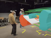
 Blog: AR/AI
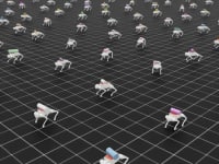
Aerial Microrobots That Can Match a Bumblebee's Speed
 News: Energy
 Blog: Electronics & Computers
Turning Edible Fungi into Organic Memristors
 Blog: Robotics, Automation & Control
Microscopic Swimming Machines that Can Sense, Respond to Surroundings
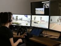
 INSIDER: Sensors/Data Acquisition
Webcasts
 Upcoming Webinars: Power
Hydrogen Engines Are Heating Up for Heavy Duty
 Upcoming Webinars: Electronics & Computers
Advantages of Smart Power Distribution Unit Design for Automotive...
 Upcoming Webinars: Transportation
Quiet, Please: NVH Improvement Opportunities in the Early Design...
 Upcoming Webinars: Sensors/Data Acquisition
From Spreadsheets to Insights: Fast Data Analysis Without Complex...
 Upcoming Webinars: Energy
Battery Abuse Testing: Pushing to Failure