Stories
42
0
1290
30
Briefs: Information Technology
Massively Parallel Dantzig-Wolfe Decomposition Applied to Traffic Flow Scheduling
Traffic flow management (TFM) of the National Airspace System (NAS) endeavors to deliver flights from their origins to their destinations while minimizing delays and respecting all capacities. There are several models for solving this problem. Some models aggregate...
Briefs: Information Technology
Flight Processor Virtualization for Size, Weight, and Power Reduction
This work demonstrated the cost-saving and fault-tolerant benefits of virtualization technology by consolidating the flight software from multiple flight processors into a single virtualized system. In this study, a flight software system that was originally deployed on six...
Briefs: Information Technology
The motivation for this research is the fact that, for a variety of reasons, networks and their existing authentication and confidentiality infrastructure are becoming more...

Briefs: Information Technology
NASA Data Acquisition System (NDAS)
The test complexes at John C. Stennis Space Center (SSC) require reliable and accurate data acquisition in order to analyze the results of rocket engine tests. Acquisition systems include high-speed data, low-speed data, event monitoring, and video feeds. In order to obtain accurate data, routine calibrations...
Briefs: Software
Time Series Product Tool (TSPT) Version 2.0
The Time Series Product Tool (TSPT) is a MATLAB-based software application that computes and displays high-quality vegetation and environmental monitoring indices from high temporal revisit rate Moderate resolution Imaging Spectroradiometer (MODIS) and other satellite sensors. The original purpose of the...
Briefs: Sensors/Data Acquisition
Integrated and Automated Software Test Environment for JPL Software Defined Radio
Software has been developed that provides an integrated and automated test environment for the Space Telecommunications Radio System (STRS). This software package is Linux based and provides interactive and scripted control to test the JPL Software Defined Radio (SDR)...
Briefs: Information Technology
System Health Monitoring Software Learns System Behavior from Data
The Inductive Monitoring System (IMS) software tool uses data mining techniques to automatically characterize nominal system operation by analyzing archived system data. These nominal characterizations are then used to perform near-real-time system health monitoring or to analyze...
News: Software
Automated Imaging System Analyzes Underground Root Systems
Researchers from the Georgia Institute of Technology and Penn State University have developed an automated imaging technique for measuring and analyzing the root systems of mature plants. The technique, believed to be the first of its kind, uses advanced computer technology to analyze...
Briefs: Information Technology
A Model-Driven Science Data Product Registration Service
The Planetary Data System (PDS) has undertaken an effort to overhaul the PDS data architecture (e.g., data model, data structures, data dictionary, etc.) and deploy a software system (online data services, distributed data catalog, etc.) that fully embraces the PDS federation as an integrated...
News: Medical
3D Printer That Could Build a Home in 24 Hours Wins Global Design Competition
New York, NY – Contour Crafting, a computerized construction method that rapidly 3D prints large-scale structures directly from architectural CAD models, has been awarded the grand prize of $20,000 in the 2014 "Create the Future" Design Contest.
Contour Crafting...
News: Imaging
Objects in space tend to spin in a way that's totally different from the way they spin on Earth. Understanding how objects are spinning, where their centers of mass are, and...
Who's Who: Software
Dr. Ajay Koshti, Lead Nondestructive Evaluation Engineer, invented NASA Flash Infrared Thermography Software. Koshti also worked as a Non-Destructive...

News: Robotics, Automation & Control
New Algorithm Lets Cheetah Robot Run
Speed and agility are hallmarks of the cheetah: The big predator is the fastest land animal on Earth, able to accelerate to 60 mph in just a few seconds. As it ramps up to top speed, a cheetah pumps its legs in tandem, bounding until it reaches a full gallop.Now MIT researchers have developed an algorithm for...
Briefs: Software
Partition Level Application Test for Orion (PLATO)
For Orion Exploration Flight Test One (EFT-1), the unit-under-test for flight software verification has been chosen as the entire integrated flight software load. At the time of this reporting, the unit test tool, while powerful, operates on very small units, usually classes. This leaves a sizable...
Briefs: Information Technology
This software simulates Sun images observed on the ground and from space with an easy-to-use analytical approach and with high accuracy. It is a simple, analytical approach with the accuracy of a...

Briefs: Software
In a crisis, up-to-date information is one of the most important commodities for decision-makers. Remote sensing data have been instrumental in regional scale damage...

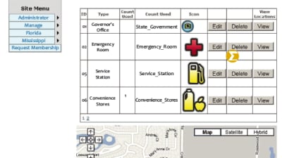
Briefs: Software
The Mississippi Evacuation and Traveler’s Assistance (MSETA) system provides public assistance for emergency evacuation and tourism/travel. The MSETA system is composed of...
Briefs: Information Technology
Exploration Visualization Environment
The Exploration Visualization Environment (EVE) is a graphical environment for the visualization, analysis, and simulation of engineering data, specializing in aerospace and aeronautic concepts. EVE is based on the history and successful application of the Synergistic Engineering Environment (SEE) and provides...
Briefs: Information Technology
Cassini Science Planning and Sequencing Team Final Sequence Approval Document Generator (Autodoc)
Documents, such as reports that are consistent in format, are excellent candidates for automation. Autodoc was designed as a means to automate such reports in order to reduce the amount of labor necessary to produce reports, and to improve the accuracy...
Briefs: Information Technology
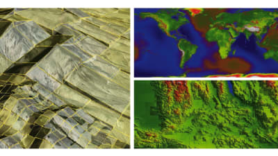
The Global Elevation Data Adaptive Compression Algorithms (GEDACA) were developed to provide compression and rapid decompression of digital terrain maps (DTMs) in constrained computing...
Briefs: Software
Multipurpose Attitude and Pointing System (MAPS) Version 6.2
MAPS is a suite of software tools used for pre-flight planning, real-time support, and post-flight analysis of spacecraft attitude and pointing for the International Space Station (ISS), HII Transfer Vehicle (HTV), Automated Transfer Vehicle (ATV), and other low Earth orbit (LEO)...
Briefs: Software
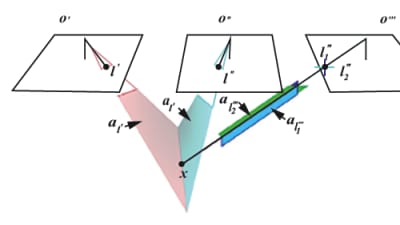
The bundle adjustment, or more specifically, the colinearity math model it is based on, is undisputedly the most accurate method to perform 3D scene reconstruction from multiple images. It...
Briefs: Physical Sciences
Quantification of Trace Chemicals Using the Vehicle Cabin Atmosphere Monitor
A software program analyzes data measured by the Vehicle Cabin Atmosphere Monitor (VCAM) and quantifies the concentrations of trace chemicals detected by VCAM. The software contains a unique way to quantify the signal measured by VCAM, to establish the concentration curve,...
Briefs: Physical Sciences
Analytical Expression of Elevation-Dependent Relative Air Mass for Atmospheric Extinction Simulations
This software enables one to calculate elevation-dependent relative air mass. When imaging a setting or rising Sun on the ground or from space, the shape and the intensity distribution of a captured image are affected by the following three...
Briefs: Physical Sciences
PACIFIC: Process Algebra Capture of Intent from Information Content
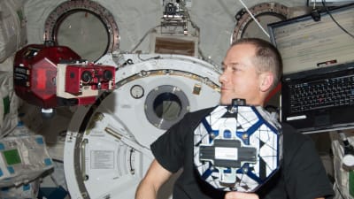
Mixed-initiative teams of robots and humans working side-by-side in close proximity to each other need to be capable of reasoning about the actions and activities of each other within a mission context. This capability requires the robotic agents to have a sense of self, and their...
Briefs: Physical Sciences
Earth Now Mobile Phone App
A mobile device application created by NASA visualizes recent global climate data from Earth science satellites, including air temperature, sea surface salinity, carbon monoxide, ozone, and water vapor, as well as gravity and sea level variations. This app is an Open GL simple 3D object viewer for the Apple IOS and...
Briefs: Physical Sciences
Using the Web Sockets Full-Duplex Communication Channel to Display Real-Time Sensor Data via Standard Web Browser
Web Sockets is a network full-duplex communication channel that allows Javascript programs embedded in Web pages to establish connections to applications running on the server that provided the Web pages. Two-way communication is...
Briefs: Software
When the space shuttle’s external tank (ET) was being filled with the cryogenic fuel components LOX and LH2, moisture from the surrounding atmosphere could condense onto the...

Briefs: Physical Sciences
Efficient Spectral Endmember Detection Onboard Spacecraft
Spaceflight and planetary exploration place severe constraints on the available bandwidth for downlinking large hyperspectral images. Communications with spacecraft often occur intermittently, so mission-relevant hyperspectral data must wait for analysis on the ground before it can inform...
Top Stories
 Blog: Robotics, Automation & Control
Aerial Microrobots That Can Match a Bumblebee's Speed
 Blog: Electronics & Computers
Turning Edible Fungi into Organic Memristors
 Blog: Manufacturing & Prototyping
Revolutionizing the Production of Semiconductor Chips
 News: Energy
 INSIDER: Electronics & Computers
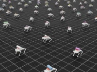
World’s Smallest Programmable, Autonomous Robots
 INSIDER: Manufacturing & Prototyping
Webcasts
 On-Demand Webinars: Power
E/E Architecture Redefined: Building Smarter, Safer, and Scalable Vehicles
 Upcoming Webinars: Energy
Hydrogen Engines Are Heating Up for Heavy Duty
 Upcoming Webinars: Electronics & Computers
Advantages of Smart Power Distribution Unit Design for Automotive...
 Upcoming Webinars: Automotive
Quiet, Please: NVH Improvement Opportunities in the Early Design...
 Upcoming Webinars: Power
A FREE Two-Day Event Dedicated to Connected Mobility
 Podcasts: Defense
How Sift's Unified Observability Platform Accelerates Drone Innovation