
A method of satellite radar interferometry (SRI) enables the remote measurement of three-dimensional velocities of ice flow over large areas of glaciers. At present, ice-flow velocities are measured primarily in situ by use of the Global Positioning System (GPS) in a time-consuming procedure that yields a limited number of data points. In previous efforts to use SRI to determine ice velocities remotely over large areas, measurements were performed along repeat passes. Unfortunately, repeat passes yield data on only the surface displacements associated with the single components of velocity along the radar lines of sight. Moreover, in the absence of additional information, there is no way to separate unambiguously the mixed horizontal and vertical displacement signals acquired via repeat-pass SRI. In contrast, the present method provides three-dimensional velocity data over large areas with horizontal sampling intervals of roughly 100 m.
In the present method, two sets of repeat-pass measurements are acquired along subsequent, nonparallel passes (one ascending, one descending). The repeat-pass measurement geometry is illustrated in the figure, wherein S1 and S2 denotes a synthetic-aperture radar (SAR) viewing the same surface point from two slightly different (near-repeat) positions at different times, and the vector B denotes the baseline between the two positions. The problem is to find the vertical component and the two horizontal components of the local displacement of the surface between the two measurement times; the local velocity components then equal these components of displacement divided by the time between acquisition of SAR images.
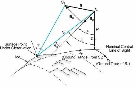
The basic interferometric quantity is the difference between the relative phases of radar signal returned from the same surface point on the two passes. This phase difference is proportional to the range difference (the difference between the distances along the lines of sight), and can be expressed as a term dependent on displacement plus a term dependent on topography. Provided that the measurement geometry (including B) is known, one can estimate the topographical term and thus isolate the displacement-dependent term. For this purpose, B is approximated as a linear function of the along-track coordinate, in a mathematical model with four parameters that are determined by a linear least-squares fit to at least four tie points.
Ordinarily, three measurements of the same surface area from three significantly different directions are necessary to measure three-dimensional velocity. However, it is difficult or impossible to acquire such data in the polar regions, where much of the ice of interest is located. In the present method, it is possible to determine all three components of velocity from measurements from only two directions: This is made possible by the assumption that the ice at the surface flows only along the surface. This assumption is somewhat unrealistic in that ice is known to flow slightly upward from the surface in an ablation zone or slightly downward from the surface in an accumulation zone. Nevertheless, the assumption is useful in that it mathematically constrains one component of velocity. The other two components are mathematically constrained by the measurements from the crossing ascending and descending passes. Thus, all three components of velocity are determined.
This work was done by Ian Joughin, Ronald Kwok of Caltech and Mark Fahnestock of the University of Maryland for NASA's Jet Propulsion Laboratory. For further information, access the Technical Support Package (TSP) free on-line at www.techbriefs.com under the Physical Sciences category, or circle no. 147on the TSP Order Card in this issue to receive a copy by mail ($5 charge). NPO-20160
This Brief includes a Technical Support Package (TSP).
Measuring velocity of ice by SRI using ascending and descending passes
(reference NPO20160) is currently available for download from the TSP library.
Don't have an account?
Overview
The document is a technical support package from NASA detailing a novel method for measuring ice flow velocity using satellite radar interferometry (SRI). The primary focus is on a technique that allows for the remote measurement of the full three-component ice-flow velocity vector, which is crucial for glaciological research. Traditional methods of measuring ice flow are limited, often providing sparse data points and only capturing single components of velocity. This new interferometric technique overcomes these limitations by utilizing data from both ascending and descending satellite passes, enabling comprehensive three-dimensional velocity estimates.
The motivation behind this development stems from the fundamental importance of understanding ice-flow velocity in glaciology, particularly in polar regions where obtaining direct measurements is challenging. The document highlights that existing techniques do not offer densely-sampled measurements over extensive, featureless areas, which creates a significant gap in data necessary for effective glaciological studies. The proposed method addresses this gap by employing a surface-parallel flow assumption, which allows for the estimation of all three components of ice flow velocity from interferometric data.
The technical disclosure outlines the problem that led to the development of this method, emphasizing the need for a more effective way to measure ice flow across large areas. The solution presented is a significant improvement over previous techniques, which were limited to measuring only one component of the velocity vector. By extending earlier interferometric methods, this new approach can provide a more comprehensive understanding of ice dynamics.
The document also includes information about the inventors, Mark Fahnestock, Ian Joughin, and Ronald Kwok, and notes that the report may be made available through tech briefs. It is part of a broader effort by NASA and the Jet Propulsion Laboratory (JPL) to advance the understanding of ice flow and its implications for climate change and sea-level rise.
In summary, this technical support package presents a significant advancement in the measurement of ice flow velocity, offering a robust method that enhances data collection over large, remote areas, thereby contributing to the field of glaciology and our understanding of ice dynamics.