42
-1
1170
30
Briefs: Software
Simulating Avionics Upgrades to the Space Shuttles
Cockpit Avionics Prototyping Environment (CAPE) is a computer program that simulates the functions of proposed upgraded avionics for a space shuttle. In CAPE, pre-existing space-shuttle-simulation programs are merged with a commercial-off-the-shelf (COTS) display-development program, yielding a...
Briefs: Software
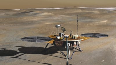
A computer program called "phxlrsim" simulates the behavior of the radar system used as an altimeter and velocimeter during the entry, descent, and landing phases of the Phoenix lander spacecraft....
Briefs: Test & Measurement
Injecting Artificial Memory Errors Into a Running Computer Program
Single-event upsets (SEUs) or "bitflips" are computer memory errors caused by radiation. BITFLIPS (Basic Instrumentation Tool for Fault Localized Injection of Probabilistic SEUs) is a computer program that deliberately injects SEUs into another computer program, while the latter is...
Briefs: Software
A computer program has been written as an essential part of an electronic temperature control system for a space-borne instrument that contains several zones. The system was developed because...

Briefs: Software
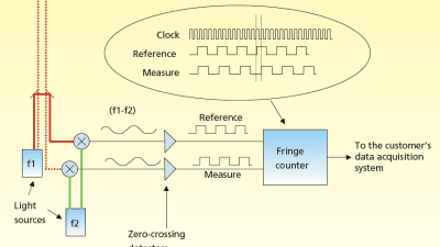
Firmware for implementing a digital phasemeter within a field-programmable gate array (FPGA) has been devised. In the original application of this firmware, the phase that one seeks to measure is the...
Briefs: Software
Post-Flight Estimation of Motion of Space Structures: Part 1
A computer program estimates the relative positions and orientations of two space structures from data on the angular positions and distances of fiducial objects on one structure as measured by a target-tracking electronic camera and laser range finders on another structure. The program...
Briefs: Software
Post-Flight Estimation of Motion of Space Structures: Part 2
A computer program related to the one described in the immediately preceding article estimates the relative position of two space structures that are hinged to each other. The input to the program consists of time-series data on distances, measured by two range finders at different...
Briefs: Software
Simulating Operation of a Large Turbofan Engine
The Commercial Modular Aero- Propulsion System Simulation (CMAPSS) is a computer program for simulating transient operation of a commercial turbofan engine that can generate as much as 90,000 lb (≈0.4 MN) of thrust. It includes a power-management system that enables simulation of open- or...
Briefs: Software
MagBear12 is a computer code (see figure) that assists in the design of radial, heteropolar active magnetic bearings (AMBs). MagBear12 was developed to help in designing the system...

Briefs: Software
Computational Simulation of a Water-Cooled Heat Pump
A Fortran-language computer program for simulating the operation of a water-cooled vapor-compression heat pump in any orientation with respect to gravity has been developed by modifying a prior general-purpose heat-pump design code used at Oak Ridge National Laboratory (ORNL). Although it is...
Briefs: Software
Computational Model of Heat Transfer on the ISS
SCRAM Lite ("SCRAM" signifies "Station Compact Radiator Analysis Model") is a computer program for analyzing convective and radiative heat transfer and heat-rejection performance of coolant loops and radiators, respectively, in the active thermal-control systems of the International Space Station...
Briefs: Software
Optimization of Angular-Momentum Biases of Reaction Wheels
RBOT [RWA Bias Optimization Tool (wherein "RWA" signifies "Reaction Wheel Assembly")] is a computer program designed for computing angular momentum biases for reaction wheels used for providing spacecraft pointing in various directions as required for scientific observations. RBOT is...
Briefs: Aerospace
Short- and Long-Term Propagation of Spacecraft Orbits
The Planetary Observer Planning Software (POPS) comprises four computer programs for use in designing orbits of spacecraft about planets. These programs are the Planetary Observer High Precision Orbit Propagator (POHOP), the Planetary Observer Long-Term Orbit Predictor (POLOP), the Planetary...
Briefs: Software
Monte Carlo Simulation To Estimate Likelihood of Direct Lightning Strikes
A software tool has been designed to quantify the lightning exposure at launch sites of the stack at the pads under different configurations. In order to predict lightning strikes to generic structures, this model uses leaders whose origins (in the x–y plane) are obtained...
Briefs: Software
Adaptive MGS Phase Retrieval
Adaptive MGS Phase Retrieval software uses the Modified Gerchberg-Saxton (MGS) algorithm, an image-based sensing method that can turn any focal plane science instrument into a wavefront sensor, avoiding the need to use external metrology equipment. Knowledge of the wavefront enables intelligent control of active optical...
Briefs: Aerospace
The BLT Prediction Tool ("BLT" signifies "Boundary Layer Transition") is provided as part of the Damage Assessment Team analysis package, which is utilized for analyzing local...

Briefs: Test & Measurement
Calculations for Calibration of a Mass Spectrometer
A computer program performs calculations to calibrate a quadrupole mass spectrometer in an instrumentation system for identifying trace amounts of organic chemicals in air. In the operation of the mass spectrometer, the mass-to-charge ratio (m/z) of ions being counted at a given instant of time is...
Briefs: Test & Measurement
Simulating the Gradually Deteriorating Performance of an RTG
Degra (now in version 3) is a computer program that simulates the performance of a radioisotope thermoelectric generator (RTG) over its lifetime. Degra is provided with a graphical user interface that is used to edit input parameters that describe the initial state of the RTG and the...
Briefs: Aerospace
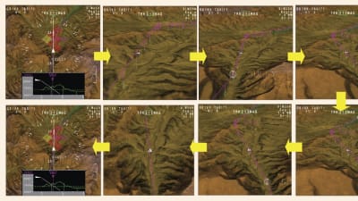
Flight-deck display software was designed and developed at NASA Langley Research Center to provide two-dimensional (2D) and three-dimensional (3D) terrain, obstacle, and flightpath perspectives on a...
Briefs: Software
Automated Camera Array Fine Calibration
Using aerial imagery, the JPL FineCalibration (JPL FineCal) software automatically tunes a set of existing CAHVOR camera models for an array of cameras. The software finds matching features in the overlap region between images from adjacent cameras, and uses these features to refine the camera models. It is...
Briefs: Software
Multichannel Networked Phasemeter Readout and Analysis
Netmeter software reads a data stream from up to 250 networked phasemeters, synchronizes the data, saves the reduced data to disk (after applying a low-pass filter), and provides a Web server interface for remote control. Unlike older phasemeter software that requires a special, real-time...
Briefs: Software
MISR Instrument Data Visualization
The MISR Interactive eXplorer (MINX) software functions both as a general-purpose tool to visualize Multiangle Imaging SpectroRadiometer (MISR) instrument data, and as a specialized tool to analyze properties of smoke, dust, and volcanic plumes. It includes high-level options to create map views of MISR orbit...
Briefs: Software
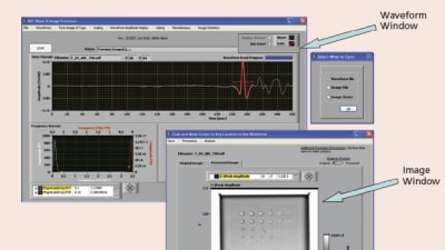
Taking advantage of the similarities that exist among all waveform-based non-destructive evaluation (NDE) methods, a common software platform has been developed containing multiple-signal and...
Briefs: Software
System for Continuous Delivery of MODIS Imagery to Internet Mapping Applications
This software represents a complete, unsupervised processing chain that generates a continuously updating global image of the Earth from the most recent available MODIS Level 1B scenes.
Briefs: Imaging
Automatic Rock Detection and Mapping from HiRISE Imagery
This system includes a C-code software program and a set of MATLAB software tools for statistical analysis and rock distribution mapping. The major functions include rock detection and rock detection validation. The rock detection code has been evolved into a production tool that can be used...
Briefs: Software
Parallel Computing for the Computed-Tomography Imaging Spectrometer
This software computes the tomographic reconstruction of spatial-spectral data from raw detector images of the Computed-Tomography Imaging Spectrometer (CTIS), which enables transient-level, multi-spectral imaging by capturing spatial and spectral information in a single snapshot....
Briefs: Software
Processing LiDAR Data To Predict Natural Hazards
ELF-Base and ELF-Hazards (wherein "ELF" signifies "Extract LiDAR Features" and "LiDAR" signifies "light detection and ranging") are developmental software modules for processing remote-sensing LiDAR data to identify past natural hazards (principally, landslides) and predict future ones. ELF-Base...
Briefs: Software
Rockster is an algorithm that automatically identifies the locations and boundaries of rocks imaged by the rover hazard cameras (hazcams), navigation cameras (navcams), or panoramic cameras (pancams)....

Briefs: Software
The DSN Array Simulator (wherein "DSN" signifies NASA's Deep Space Network) is an updated version of software previously denoted the DSN Receive Array Technology Assessment Simulation. This software (see figure) is used for...

Top Stories
 Blog: Power
My Opinion: We Need More Power Soon — Is Nuclear the Answer?
 Blog: AR/AI
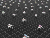
Aerial Microrobots That Can Match a Bumblebee's Speed
 News: Energy
 Blog: Electronics & Computers
Turning Edible Fungi into Organic Memristors
 Blog: Robotics, Automation & Control
Microscopic Swimming Machines that Can Sense, Respond to Surroundings
 INSIDER: Sensors/Data Acquisition
Webcasts
 Upcoming Webinars: Energy
Hydrogen Engines Are Heating Up for Heavy Duty
 Upcoming Webinars: Transportation
Advantages of Smart Power Distribution Unit Design for Automotive...
 Upcoming Webinars: Automotive
Quiet, Please: NVH Improvement Opportunities in the Early Design...
 Upcoming Webinars: Test & Measurement
From Spreadsheets to Insights: Fast Data Analysis Without Complex...
 Upcoming Webinars: Power
Battery Abuse Testing: Pushing to Failure