Stories
42
0
1800
30
Articles: Software
In our annual poll of executives at leading analysis and simulation software companies, we asked about the economic situation’s effect on the market, the pros and cons of virtual prototyping,...
Blog: Software
Lightning Strikes With PTC's Creo
There was a bit of a crowd lining up near Boston's Park Plaza this morning, and if it wasn't for all the business-casual attire, you may have thought another Apple Store was opening up down the street. The event was actually PTC's unveiling of its new product suite: Creo.
Here's the quick rundown:
Creo is a suite...
Briefs: Software
Platform for Post-Processing Waveform-Based NDE
Signal- and image-processing methods are commonly needed to extract information from the waves, improve resolution of, and highlight defects in an image. Since some similarity exists for all waveform-based nondestructive evaluation (NDE) methods, it would seem that a common software platform...
Briefs: Software
BGen: A UML Behavior Network Generator Tool
BGen software was designed for auto-generation of code based on a graphical representation of a behavior network used for controlling automatic vehicles. A common format used for describing a behavior network, such as that used in the JPL-developed behavior-based control system, CARACaS [“Control...
Application Briefs: Software
Geomagic Studio 3D scanning and processing softwareGeomagic Inc.Research Triangle Park, NC800-691-1839 www.geomagic.com
Ceramic tiles used on the underside of the...
Articles: Green Design & Manufacturing
You might think a wind turbine would have more in common with a plane’s propeller than an aircraft wing, but wind blades actually...
Briefs: Information Technology
Hidden Statistics Approach to Quantum Simulations
Recent advances in quantum information theory have inspired an explosion of interest in new quantum algorithms for solving hard computational (quantum and non-quantum) problems. The basic principle of quantum computation is that the quantum properties can be used to represent structure data, and...
Briefs: Software
Numerical Mean Element Orbital Analysis With Morbiter
The Morbiter software numerically averages an osculating orbit’s equations of motion (EOM) to arrive at the mean orbit’s EOMs, which are then numerically propagated to obtain the long-term orbital ephemerides. The long-term evolution characteristics, and stability, of an orbit are best...
Briefs: Software
Phenological Parameters Estimation Tool
The Phenological Parameters Estimation Tool (PPET) is a set of algorithms implemented in MATLAB that estimates key vegetative phenological parameters. For a given year, the PPET software package takes in temporally processed vegetation index data (3D spatio-temporal arrays) generated by the time series...
Briefs: Software
World Wide Web Metaphors for Search Mission Data
A software program that searches and browses mission data emulates a Web browser, containing standard metaphors for Web browsing. By taking advantage of back-end URLs, users may save and share search states. Also, since a Web interface is familiar to users, training time is reduced. Familiar back and...
Articles: Software
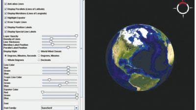
The NASA World Wind Java computer program developed at Ames Research Center at Moffett Field, CA, has won NASA’s 2009 Software of the Year award. Software engineers at Ames created the NASA World Wind...
Briefs: Software
GOATS - Orbitology Component
The GOATS Orbitology Component software was developed to specifically address the concerns presented by orbit analysis tools that are often written as stand-alone applications. These applications do not easily interface with standard JPL first-principles analysis tools, and have a steep learning curve due to their...
Briefs: Software
Research has revealed distinct spatial and temporal distributions of lightning occurrence that are strongly influenced by large-scale atmospheric flow regimes. It was believed there were two flow systems, but...

Briefs: Software
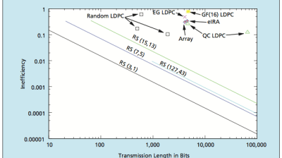
Short-block low-density parity-check (LDPC) codes of a special type are intended to be especially well suited for potential applications that include transmission of command and control data, cellular...

Briefs: Software
Deep space communications over noisy channels lead to certain packets that are not decodable. These packets leave gaps, or bursts of erasures, in the data stream. Burst erasure correcting codes...
Briefs: Software
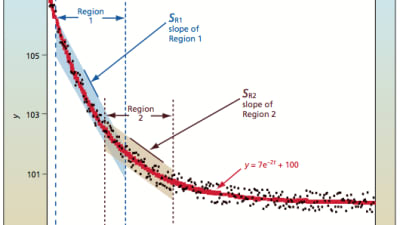
An improved solution for curve fitting data to an exponential equation (y = AeBt + C) has been developed. This improvement is in four areas — speed, stability, determinant processing...
Briefs: Software
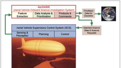
The Aerial Onboard Autonomous Science Investigation System (AerOASIS) system provides autonomous planning and execution capabilities for aerial vehicles (see figure). The system is capable of...
Briefs: Software
SCRUB is a code review tool that supports both large, team-based software development efforts (e.g., for mission software) as well as individual tasks. The tool was developed at JPL to...

Briefs: Software
A software program provides a Sensorweb architecture for alert-processing, event detection, asset allocation and planning, and visualization (see figure). It automatically tasks and...

Briefs: Software
SMART is a uniform automated discrepancy analysis and repair-authoring platform that improves technical accuracy and timely delivery of repair procedures for a given discrepancy (see figure a)....

Briefs: Software
The Navigation Ancillary Information Facility (NAIF) at JPL, acting under the direction of NASA’s Office of Space Science, has built a data system named SPICE (Spacecraft Planet Instrument C-matrix Events) to assist...

Briefs: Software
Software was developed that automatically detects minerals that are present in each pixel of a hyperspectral image. An algorithm based on sparse spectral unmixing with Bayesian...

Briefs: Software
XMbodyinfo was designed to evaluate potential reference trajectories, providing a proficient way to assess the quality of all satellite body flybys for a Cassini type mission tour. It is autonomous and will generate a variety of ORS...
Briefs: Software
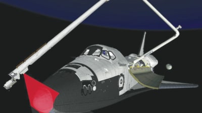
Stereo Imaging Tactical Helper
The Stereo Imaging Tactical Helper (SITH) program displays left and right images in stereo using the display technology made available by the JADIS framework, which was described in “JAVA Stereo Display Toolkit,” NASA Tech Briefs, Vol. 32, No. 4 (April 2008), page 63. An overlay of the surface described by the...
Briefs: Software
Real-Time Feature Tracking Using Homography
This software finds feature point correspondences in sequences of images. It is designed for feature matching in aerial imagery. Feature matching is a fundamental step in a number of important image processing operations: calibrating the cameras in a camera array, stabilizing images in aerial movies,...
Briefs: Software
Space Images for NASA/JPL is an Apple iPhone application that allows the general public to access featured images from the Jet Propulsion Laboratory (JPL). A back-end infrastructure stores, tracks, and retrieves space...

Briefs: Software
The Autonomous Exploration for Gathering Increased Science System (AEGIS) provides automated targeting for remote sensing instruments on the Mars Exploration Rover (MER) mission, which at...

Briefs: Software
The iPatch computer code for intelligently patching surface grids was developed to convert conceptual geometry to computational fluid dynamics (CFD) geometry (see figure). It...

Briefs: Software
Operation Program for the Spatially Phase-Shifted Digital Speckle Pattern Interferometer — SPS-DSPI
SPS-DSPI software has been revised so that Goddard optical engineers can operate the instrument, instead of data programmers. The user interface has been improved to view the data collected by the SPS-DSPI, with a real-time mode and a play-back...
Top Stories
 Blog: Robotics, Automation & Control
Aerial Microrobots That Can Match a Bumblebee's Speed
 Blog: Electronics & Computers
Turning Edible Fungi into Organic Memristors
 Blog: Manufacturing & Prototyping
Revolutionizing the Production of Semiconductor Chips
 News: Energy
 INSIDER: Electronics & Computers
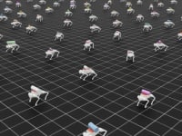
World’s Smallest Programmable, Autonomous Robots
 INSIDER: Manufacturing & Prototyping
Webcasts
 On-Demand Webinars: Power
E/E Architecture Redefined: Building Smarter, Safer, and Scalable Vehicles
 Upcoming Webinars: Energy
Hydrogen Engines Are Heating Up for Heavy Duty
 Upcoming Webinars: Electronics & Computers
Advantages of Smart Power Distribution Unit Design for Automotive...
 Upcoming Webinars: Automotive
Quiet, Please: NVH Improvement Opportunities in the Early Design...
 Upcoming Webinars: Power
A FREE Two-Day Event Dedicated to Connected Mobility
 Podcasts: Defense
How Sift's Unified Observability Platform Accelerates Drone Innovation