Stories
8,33,42,44,45,47,52,54,68
0
6240
30
News: Energy
North Carolina State University researchers have created flower-like structures out of germanium sulfide (GeS) – a semiconductor material – that have extremely thin petals with an enormous...

Question of the Week: Green Design & Manufacturing
Should Pearl Harbor "go green?"
As part of the Navy's plan to convert at least 50% of its energy demands to alternative sources by 2020, the branch may cover part of Pearl Harbor with solar panels. The 4000-foot, unused runway in the center of Pearl Harbor's military base is a good location for the solar project and is "critically important to...
News: Defense
Miniature Atomic Clock Could Support Soldiers In Absence Of GPS
The U.S. Army has begun the final phase for manufacturing a microchip-sized prototype that will support efforts to provide highly accurate location and battlefield situational awareness for the dismounted soldier, even in the temporary absence of GPS capability.
News: Test & Measurement
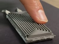
New Technique Monitors Semiconductor Surface as it is Etched
University of Illinois researchers have a new low-cost method to carve delicate features onto semiconductor wafers using light – and watch as it happens. The team’s new technique can monitor a semiconductor’s surface as it is etched, in real time, with nanometer resolution. It uses...
Briefs: Electronics & Computers
Wideband Single-Crystal Transducer for Bone Characterization
The microgravity conditions of space travel result in unique physiological demands on the human body. In particular, the absence of the continual mechanical stresses on the skeletal system that are present on Earth cause the bones to decalcify. Trabecular structure decreases in thickness...
Briefs: Software
Stereo and IMU-Assisted Visual Odometry for Small Robots
This software performs two functions: (1) taking stereo image pairs as input, it computes stereo disparity maps from them by cross-correlation to achieve 3D (three-dimensional) perception; (2) taking a sequence of stereo image pairs as input, it tracks features in the image sequence to...
Briefs: Software
Global Swath and Gridded Data Tiling
This software generates cylindrically projected tiles of swath-based or gridded satellite data for the purpose of dynamically generating high-resolution global images covering various time periods, scaling ranges, and colors called “tiles.” It reconstructs a global image given a set of tiles covering a...
Briefs: Software
GOES-R: Satellite Insight
GOES-R: Satellite Insight seeks to bring awareness of the GOES-R (Geostationary Operational Environmental Satellite — R Series) satellite currently in development to an audience of all ages on the emerging medium of mobile games. The iPhone app (Satellite Insight) was created for the GOES-R Program. The app describes in...
Briefs: Software
Aquarius iPhone Application
The Office of the CIO at JPL has developed an iPhone application for the Aquarius/SAC-D mission. The application includes specific information about the science and purpose of the Aquarius satellite and also features daily mission news updates pulled from sources at Goddard Space Flight Center as well as Twitter. The...
Briefs: Information Technology
Monitoring of International Space Station Telemetry Using Shewhart Control Charts
Shewhart control charts have been established as an expedient method for analyzing dynamic, trending data in order to identify anomalous subsystem performance as soon as such performance would exceed a statistically established baseline. Additionally, this leading...
Briefs: Information Technology
Time Manager Software for a Flight Processor
Data analysis is a process of inspecting, cleaning, transforming, and modeling data to highlight useful information and suggest conclusions. Accurate timestamps and a timeline of vehicle events are needed to analyze flight data. When data is gathered onboard a rocket, precise time stamping is even more...
Briefs: Information Technology
Simulation of Oxygen Disintegration and Mixing With Hydrogen or Helium at Supercritical Pressure
The simulation of high-pressure turbulent flows, where the pressure, p, is larger than the critical value, pc, for the species under consideration, is relevant to a wide array of propulsion systems, e.g. gas turbine, diesel, and liquid rocket engines....
Briefs: Information Technology
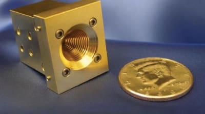
Theory of a Traveling Wave Feed for a Planar Slot Array Antenna
Planar arrays of waveguide-fed slots have been employed in many radar and remote sensing applications. Such arrays are designed in the standing wave configuration because of high efficiency. Traveling wave arrays can produce greater bandwidth at the expense of efficiency due to power...
Briefs: Electronics & Computers
Radiation-Tolerant DC-DC Converters
A document discusses power converters suitable for space use that meet the DSCC MIL-PRF-38534 Appendix G radiation hardness level P classification. A method for qualifying commercially produced electronic parts for DC-DC converters per the Defense Supply Center Columbus (DSCC) radiation hardened assurance...
Application Briefs: Electronics & Computers
Lockheed Martin Space Systems Advanced Technology Center (ATC) has completed delivery of hardware subsystems for NASA’s Magnetospheric Multiscale (MMS) Mission. The delivery...

Briefs: Information Technology
Rugged, Portable, Real-Time Optical Gaseous Analyzer for Hydrogen Fluoride
Hydrogen fluoride (HF) is a primary evolved combustion product of fluorinated and perfluorinated hydrocarbons. HF is produced during combustion by the presence of impurities and hydrogen-containing polymers including polyimides. This effect is especially dangerous in closed...
Briefs: Information Technology
The avionics system software for human-rated launch vehicles requires an implementation approach that is robust to failures, especially the failure of sensors used to monitor...

Briefs: Electronics & Computers
A three-frequency millimeter-wave feed horn was developed as part of an advanced component technology task that provides components necessary for higher-frequency radiometers to meet the...
Briefs: Electronics & Computers
Online Cable Tester and Rerouter
Hardware and algorithms have been developed to transfer electrical power and data connectivity safely, efficiently, and automatically from an identified damaged/defective wire in a cable to an alternate wire path. The combination of online cable testing capabilities, along with intelligent signal rerouting...
Briefs: Electronics & Computers
Inverted Three-Junction Tandem Thermophotovoltaic Modules
An InGaAs-based three-junction (3J) tandem thermophotovoltaic (TPV) cell has been investigated to utilize more of the blackbody spectrum (from a 1,100 °C general purpose heat source — GPHS) efficiently. The tandem consists of three vertically stacked subcells, a 0.74-eV InGaAs cell, a...
Briefs: Electronics & Computers
Capacitance Probe Resonator for Multichannel Electrometer
A multichannel electrometer voltmeter has been developed that employs a mechanical resonator with voltage-sensing capacitance-probe electrodes that enable high-impedance, high-voltage, radiation-hardened measurement of an Internal Electrostatic Discharge Monitor (IESDM) sensor. The IESDM is...
News: Materials
Engineering researchers at Rensselaer Polytechnic Institute made a sheet of paper from the world’s thinnest material, graphene, and then zapped the paper with a laser or camera flash...

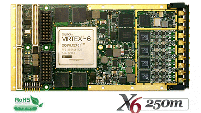
INSIDER Product: Electronics & Computers
Innovative Integration (Simi Valley, CA) has announced the new X6-250M that integrates digitizing with signal processing on a PMC/XMC IO module. The module has a powerful Xilinx Virtex 6 FPGA signal processing core, and high...
INSIDER Product: Electronics & Computers
Texas Instruments Incorporated (TI) (Dallas, TX) has introduced the DS90UB913Q serializer and DS90UB914Q deserializer, the newest additions to its FPD-Link III automotive-grade chipset family. The SerDes chipset...

INSIDER Product: Electronics & Computers
Pentek, Inc. (Upper Saddle River, NJ) has introduced an ultra wide-band RF/IF rackmount recorder, the Talon(TM) RTS 2709. Using 12-bit, 3.6 GHz A/D converters and state-of-the-art solid state drive storage...
INSIDER Product: Electronics & Computers
ADLINK Technology, Inc. (San Jose, CA) has announced availability of the cPCI-6930, a next-generation 6U dual-slot CompactPCI(R) (cPCI) processor blade with flexible expansion capabilities. The cPCI-6930 features a 1.8 GHz eight-core...

Products: Energy
SAKOR Technologies, Inc. (Okemos, MI) designed and installed a complete turnkey Hybrid and Electric Vehicle Test System for UQM Technologies, Inc. (Longmont, CO), a manufacturer of high-efficiency...

News: Electronics & Computers
Vanderbilt University researches have developed a way to combine Photosystem 1 (PS1), the photosynthetic protein that converts light into electrochemical energy in spinach with silicon (the material used in...

News: Test & Measurement
Researchers Use Simulated Sunlight to Test PV Efficiency
PML researchers have devised a novel source of portable sunlight that may fill an urgent need in renewable energy research – namely, light sources that generate a near-perfect solar spectrum to be used in testing the performance and efficiency of photovoltaic (PV) materials.The team’s...
Top Stories
 Blog: Power
My Opinion: We Need More Power Soon — Is Nuclear the Answer?
 Blog: AR/AI
Aerial Microrobots That Can Match a Bumblebee's Speed
 News: Energy
 Blog: Electronics & Computers
Turning Edible Fungi into Organic Memristors
 Blog: Robotics, Automation & Control
Microscopic Swimming Machines that Can Sense, Respond to Surroundings
 INSIDER: Sensors/Data Acquisition
Webcasts
 Upcoming Webinars: Power
Hydrogen Engines Are Heating Up for Heavy Duty
 Upcoming Webinars: Electronics & Computers
Advantages of Smart Power Distribution Unit Design for Automotive...
 Upcoming Webinars: Transportation
Quiet, Please: NVH Improvement Opportunities in the Early Design...
 Upcoming Webinars: Sensors/Data Acquisition
From Spreadsheets to Insights: Fast Data Analysis Without Complex...
 Upcoming Webinars: Energy
Battery Abuse Testing: Pushing to Failure