
This computing environment is the next generation of geodetic image processing technology for repeat-pass Interferometric Synthetic Aperture (InSAR) sensors, identified by the community as a needed capability to provide flexibility and extensibility in reducing measurements from radar satellites and aircraft to new geophysical products. This software allows users of interferometric radar data the flexibility to process from Level 0 to Level 4 products using a variety of algorithms and for a range of available sensors.
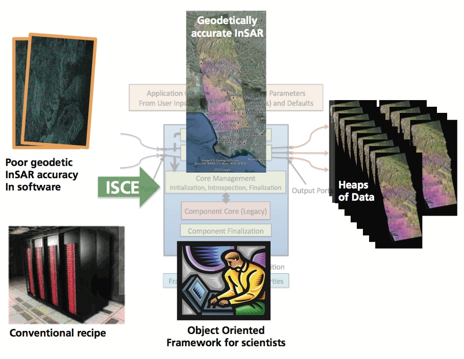
This software implements an accurate, extensible, and modular processing system designed to realize the full potential of InSAR data from future missions such as the proposed DESDynI, existing radar satellite data, as well as data from the NASA UAVSAR (Uninhabited Aerial Vehicle Synthetic Aperture Radar), and other airborne platforms. The processing approach has been re-thought in order to enable multi-scene analysis by adding new algorithms and data interfaces, to permit user-reconfigurable operation and extensibility, and to capitalize on codes already developed by NASA and the science community. The framework incorporates modern programming methods based on recent research, including object-oriented scripts controlling legacy and new codes, abstraction and generalization of the data model for efficient manipulation of objects among modules, and well-designed module interfaces suitable for command-line execution or GUI-programming. The framework is designed to allow users’ contributions to promote maximum utility and sophistication of the code, creating an open-source community that could extend the framework into the indefinite future.
This work was done by Paul A. Rosen, Gian Franco Sacco, and Eric M. Gurrola of JPL/Caltech; and Howard A. Zebker of Stanford University for NASA’s Jet Propulsion Laboratory.
This software is available for commercial licensing. Please contact Daniel Broderick of the California Institute of Technology at
This Brief includes a Technical Support Package (TSP).
InSAR Scientific Computing Environment
(reference NPO-47557) is currently available for download from the TSP library.
Don't have an account?
Overview
The document outlines the development and goals of the InSAR Scientific Computing Environment (ISCE), a project aimed at enhancing the processing capabilities of Interferometric Synthetic Aperture Radar (InSAR) data. The initiative is a response to the needs identified by the international community of radar processor developers and users during two NASA-sponsored InSAR workshops held in 2008 and 2011.
The 2008 workshop focused on assessing existing InSAR processing packages, identifying their strengths and weaknesses, and defining the requirements for next-generation processors. Key recommendations from this workshop emphasized the need for software that is accurate, extensible, modular, efficient, well-documented, and accessible to users. Additionally, the software should be portable, open-source, thoroughly tested, and capable of producing reproducible results.
The 2011 workshop aimed to validate the accuracy and performance of various non-commercial InSAR processing packages, generating feedback for further development. This collaborative effort was supported by NASA's Earth Surface and Interior Program and involved contributions from institutions such as Stanford University and the Scripps Institution of Oceanography.
The document also highlights the key drivers behind the ISCE architecture, which include preserving the expertise embedded in legacy software, streamlining auxiliary tasks, and implementing modern object-oriented structures. The architecture aims to enhance user configuration and allow for the dynamic selection of processing functions at runtime.
Acknowledgments in the document credit several individuals, including PhD candidates and postdoctoral researchers from Stanford University and Caltech, for their contributions to the legacy code that forms the foundation of ISCE. The work was performed at the Jet Propulsion Laboratory (JPL) under NASA contracts, emphasizing the collaborative nature of the project.
Overall, the ISCE project represents a significant advancement in the field of InSAR processing, aiming to provide a robust, user-friendly, and efficient software environment for researchers and developers in the geosciences. The document serves as a technical support package, providing insights into the goals, architecture, and collaborative efforts behind this innovative initiative. For further information, it directs readers to contact the Innovative Technology Assets Management at JPL.