
An automated ground facility, for vicarious radiometric calibration of airborne and spaceborne sensors of visible and infrared light has been established. In the term “vicarious calibration,” “vicarious” is used in the sense of “in place of another,” signifying “in place of laboratory calibration.” Vicarious calibration involves the use of ground truth in the form of measurements by ground-viewing radiometers, a Sun- viewing photometer, and meteorological instruments positioned in a ground target area. Typically, the target is a dry lakebed or other relatively homogeneous area. (The value of a relatively homogeneous target is that it minimizes effects of errors of registration between the target and the fields of view of sensors.) The measurement data are processed by a radiative- transfer computer code to estimate spectral radiances at the position of a sensor known to be overhead at the time of the measurements. These radiances can be compared with the sensor readings to calibrate the sensor.
Previously, in order to perform vicarious calibration, it was necessary to dispatch field teams on expensive measurement campaigns to target sites, scheduled in accordance with sensor overpass times and weather conditions. Difficulty was compounded by remoteness and limited accessibility of typical targets. The present ground facility nearly eliminates the need for field measurement campaigns by acquiring data nearly continuously and making the data available to all interested parties via the World Wide Web.
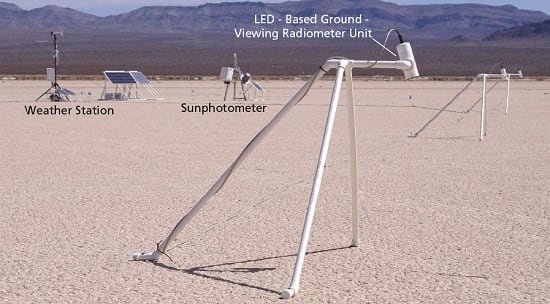
The present ground facility occupies a target site consisting of the Frenchman Flat dry lakebed located north-northeast of Mercury, Nevada. The instrumentation at the facility includes a light-emitting-diode spectrometer (LSpec), which consists of eight tripod-mounted, ground-viewing radiometer units containing LEDs biased to operate as photodetectors (instead of light emitters) at their respective wavelengths. The LSpec provides an essentially continuous stream of measurements at eight discrete wavelengths. These are merged with spectral surface-reflectance measurements made on occasional site visits to obtain temporally continuous coverage with high spectral resolution. Other equipment at the site includes a weather station and a tracking sunphotometer (see figure).
Measurement data are acquired at intervals of 5 minutes under all daylight conditions. The data are entered into a database maintained on a Jet Propulsion Laboratory server computer. A remote user can log into a Web- based interface and request information specific to the overpass time of a given sensor. The data can be fed as input to the radiative-transfer computer program to obtain radiances for calibration of the sensor.
This work was done by Carol Bruegge and Shannon Jackson of Caltech and Mark Helmlinger of Northrop Grumman Space Technology for NASA’s Jet Propulsion Laboratory.
NPO-45425
This Brief includes a Technical Support Package (TSP).

Ground Facility for Vicarious Calibration of Skyborne Sensors
(reference NPO-45425) is currently available for download from the TSP library.
Don't have an account?
Overview
The document is a Technical Support Package for the Ground Facility for Vicarious Calibration of Skyborne Sensors, identified as NPO-45425, produced by NASA's Jet Propulsion Laboratory (JPL). It outlines the development and capabilities of the LSpec Automated Vicarious Calibration Facility, which is designed to provide essential ground truth data for the calibration of remote sensing instruments, particularly hyperspectral and multispectral sensors.
The LSpec concept focuses on delivering on-demand ground truth data over homogeneous targets, accessible to registered users via a public website. This facility is equipped with advanced technologies for spectral surface monitoring, in-situ sunphotometry, and meteorological data collection, all supported by a robust power and communications infrastructure. The system is designed to operate in remote locations, making it versatile for various applications in environmental monitoring and research.
The document highlights the technical specifications of the facility, including the use of two 115 W solar panels charging two 65 Ah Optima deep-cycle batteries, ensuring that power is not a limiting factor for future expansions. The facility's capabilities allow for the generation of hyperspectral Top of Atmosphere (TOA) radiance estimates, which are crucial for the absolute calibration of visible and near-infrared (VNIR) imaging remote sensing instruments. Additionally, it can accommodate multispectral instruments through band function convolution and out-of-band response adjustments.
The information provided in this document is part of NASA's Commercial Technology Program, aimed at disseminating aerospace-related developments with broader technological, scientific, or commercial applications. It emphasizes the importance of vicarious calibration in enhancing the accuracy of remote sensing data, which is vital for various applications, including climate monitoring, agricultural assessments, and environmental studies.
For further inquiries or assistance, the document provides contact information for the Innovative Technology Assets Management at JPL, encouraging collaboration and engagement with the broader scientific community. Overall, this Technical Support Package serves as a comprehensive resource for understanding the capabilities and applications of the LSpec facility in advancing remote sensing technologies.