Stories
42
0
1530
30
Briefs: Software
Software Modules for the Proximity-1 Space Link Interleaved Time Synchronization (PITS) Protocol
The Proximity-1 Space Link Interleaved Time Synchronization (PITS) protocol provides time distribution and synchronization services for space systems. A software prototype implementation of the PITS algorithm has been developed that also provides the...
Briefs: Software
Extended Testability Analysis Tool
The Extended Testability Analysis (ETA) Tool is a software application that supports fault management (FM) by performing testability analyses on the fault propagation model of a given system. Fault management includes the prevention of faults through robust design margins and quality assurance methods, or the...
Briefs: Software
AdapChem
AdapChem software enables high efficiency, low computational cost, and enhanced accuracy on computational fluid dynamics (CFD) numerical simulations used for combustion studies. The software dynamically allocates smaller, reduced chemical models instead of the larger, full chemistry models to evolve the calculation while ensuring the same...
Briefs: Software
Description and User Instructions for the Quaternion_to_orbit_v3 Software
For a given inertial frame of reference, the software combines the spacecraft orbits with the spacecraft attitude quaternions, and rotates the body-fixed reference frame of a particular spacecraft to the inertial reference frame. The conversion assumes that the two spacecraft...
Articles: Mechanical & Fluid Systems
Thermal Stir Welding Process
Jeff Ding NASA Marshall Space Flight Center, Alabama
The patented thermal stir welding process is a new solid-state (meaning the weld metal does...

Articles: Lighting
Grid-X Cloud and Smartphone Accelerator
James Awrach SeaFire Micros, Beverly, MA
Supercomputers are linked worldwide, creating ultra-highperformance cloud, utility, and grid...

Articles: Software
Mark Wagner, Ben Madoff, and Mark Rudolph Sensorcon, Buffalo, NY
What if sensors, meters, and instruments were just apps instead of single-purpose, bulky, expensive equipment? Sensordrone is a first step towards making this...
Articles: Software
In our annual poll of executives at leading analysis and simulation software vendors, we found that more widespread use of the cloud, mobile devices, and touchscreen interfaces will be major...

Briefs: Software
MPST Software: MoonKommand
This software automatically processes Sally Ride Science (SRS) delivered MoonKAM camera control files (ccf) into uplink products for the GRAIL-A and GRAIL-B spacecraft as part of an education and public outreach (EPO) extension to the Grail Mission. Once properly validated and deemed safe for execution onboard the...
Briefs: Software
HURON (HUman and Robotic Optimization Network) Multi-Agent Temporal Activity Planner/ Scheduler
HURON solves the problem of how to optimize a plan and schedule for assigning multiple agents to a temporal sequence of actions (e.g., science tasks). Developed as a generic planning and scheduling tool, HURON has been used to optimize space mission...
Briefs: Software
QuakeSim 2.0
QuakeSim 2.0 improves understanding of earthquake processes by providing modeling tools and integrating model applications and various heterogeneous data sources within a Web services environment. QuakeSim is a multi-source, synergistic, data-intensive environment for modeling the behavior of earthquake faults individually, and as part...
Briefs: Software
Surface Temperature Data Analysis
Small global mean temperature changes may have significant to disastrous consequences for the Earth’s climate if they persist for an extended period. Obtaining global means from local weather reports is hampered by the uneven spatial distribution of the reliably reporting weather stations. Methods had to be...
Briefs: Software
Visual System for Browsing, Analysis, and Retrieval of Data (ViSBARD)
ViSBARD software provides a way of visualizing multiple vector and scalar quantities as measured by many spacecraft at once. The data are displayed three-dimensionally along the orbits that may be shown either as connected lines or as points. The data display allows the rapid...
News: Software
Counter-IED Software Developed at West Point Supports Warfighters
Three West Point cadets spent part of their summer secluded in a locked research lab with its windows blackened. Their project involved a new piece of software that can identify the location of weapons caches in theater using a mathematical model, based on the research theory of...
Briefs: Software
Aquarius iPhone Application
The Office of the CIO at JPL has developed an iPhone application for the Aquarius/SAC-D mission. The application includes specific information about the science and purpose of the Aquarius satellite and also features daily mission news updates pulled from sources at Goddard Space Flight Center as well as Twitter. The...
Briefs: Software
GOES-R: Satellite Insight
GOES-R: Satellite Insight seeks to bring awareness of the GOES-R (Geostationary Operational Environmental Satellite — R Series) satellite currently in development to an audience of all ages on the emerging medium of mobile games. The iPhone app (Satellite Insight) was created for the GOES-R Program. The app describes in...
Briefs: Software
Global Swath and Gridded Data Tiling
This software generates cylindrically projected tiles of swath-based or gridded satellite data for the purpose of dynamically generating high-resolution global images covering various time periods, scaling ranges, and colors called “tiles.” It reconstructs a global image given a set of tiles covering a...
Briefs: Software
Stereo and IMU-Assisted Visual Odometry for Small Robots
This software performs two functions: (1) taking stereo image pairs as input, it computes stereo disparity maps from them by cross-correlation to achieve 3D (three-dimensional) perception; (2) taking a sequence of stereo image pairs as input, it tracks features in the image sequence to...
Application Briefs: Software
The Mars Science Laboratory (MSL), developed at NASA’s Jet Propulsion Laboratory (JPL) in Pasadena, CA, was designed to determine whether the Gale Crater on Mars ever had conditions favorable...

Briefs: Information Technology
Leveraging Cloud Computing to Improve Storage Durability, Availability, and Cost for MER Maestro
The Maestro for MER (Mars Exploration Rover) software is the premiere operation and activity planning software for the Mars rovers, and it is required to deliver all of the processed image products to scientists on demand. These data span multiple...
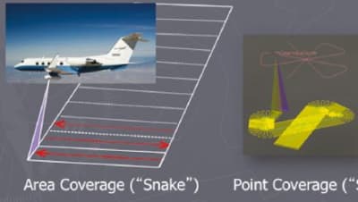
Briefs: Information Technology
I-FORCAST (Instrument – Field of Regard Coverage Analysis and Simulation Tool) is a flight planning tool specifically designed for quickly verifying the feasibility and estimating the cost of airborne...
Briefs: Software
Ascent/Descent Software
The Ascent/Descent Software Suite has been used to support a variety of NASA Shuttle Program mission planning and analysis activities, such as range safety, on the Integrated Planning System (IPS) platform. The Ascent/Descent Software Suite, containing Ascent Flight Design (ASC)/Descent Flight Design (DESC) Configuration...
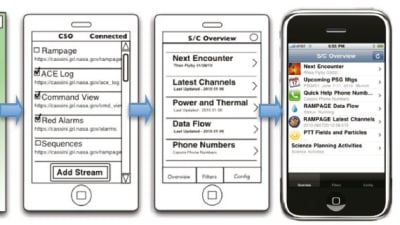
Briefs: Software
At the time of this reporting, there are 2,589 rich mobile devices used at JPL, including 1,550 iPhones and 968 Blackberrys. Considering a total JPL population of 5,961 employees, mobile applications have a total...
Briefs: Software
NASA is interested in designing a spacecraft capable of visiting a near- Earth object (NEO), performing experiments, and then returning safely. Certain...
Briefs: Software
WMS Server 2.0
This software is a simple, yet flexible server of raster map products, compliant with the OGC WMS 1.1.1 protocol. The server is a full implementation of the OGC WMS 1.1.1 as a fastCGI client and using GDAL for data access. The server can operate in a proxy mode, where all or part of the WMS requests are done on a back server.
Briefs: Software
SE-FIT
The mathematical theory of capillary surfaces has developed steadily over the centuries, but it was not until the last few decades that new technologies have put a more urgent demand on a substantially more qualitative and quantitative understanding of phenomena relating to capillarity in general. So far, the new theory development...
Briefs: Software
A successful policy negotiation scheme for Policy-Based Management (PBM) has been implemented. Policy negotiation is the process of determining the “best” communication...

Briefs: Information Technology
Scalable Integrated Multi-Mission Support System Simulator Release 3.0
The Scalable Integrated Multi-mission Support System (SIMSS) is a tool that performs a variety of test activities related to spacecraft simulations and ground segment checks.
Briefs: Information Technology
FERMI/GLAST Integrated Trending and Plotting System Release 5.0
An Integrated Trending and Plotting System (ITPS) is a trending, analysis, and plotting system used by space missions to determine performance and status of spacecraft and its instruments. ITPS supports several NASA mission operational control centers providing engineers, ground...
Top Stories
 Blog: Robotics, Automation & Control
Aerial Microrobots That Can Match a Bumblebee's Speed
 Blog: Electronics & Computers
Turning Edible Fungi into Organic Memristors
 Blog: Manufacturing & Prototyping
Revolutionizing the Production of Semiconductor Chips
 News: Energy
 INSIDER: Electronics & Computers
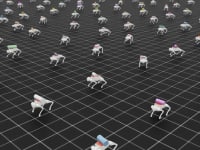
World’s Smallest Programmable, Autonomous Robots
 INSIDER: Manufacturing & Prototyping
Webcasts
 On-Demand Webinars: Power
E/E Architecture Redefined: Building Smarter, Safer, and Scalable Vehicles
 Upcoming Webinars: Energy
Hydrogen Engines Are Heating Up for Heavy Duty
 Upcoming Webinars: Electronics & Computers
Advantages of Smart Power Distribution Unit Design for Automotive...
 Upcoming Webinars: Automotive
Quiet, Please: NVH Improvement Opportunities in the Early Design...
 Upcoming Webinars: Power
A FREE Two-Day Event Dedicated to Connected Mobility
 Podcasts: Defense
How Sift's Unified Observability Platform Accelerates Drone Innovation