
Glaciers and ice sheets modulate global sea level by storing water deposited as snow on the surface, and discharging water back into the ocean through melting. Their physical state can be characterized in terms of their mass balance and dynamics. To estimate the current ice mass balance, and to predict future changes in the motion of the Greenland and Antarctic ice sheets, it is necessary to know the ice sheet thickness and the physical conditions of the ice sheet surface and bed. This information is required at fine resolution and over extensive portions of the ice sheets.
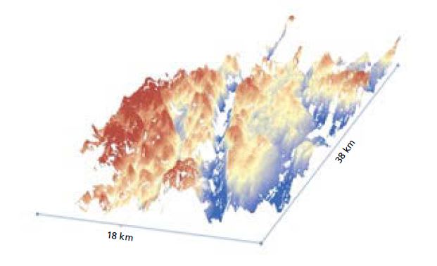
In this innovative development supported in part by NASA ESTO, airborne tomographic ice sounding technology was used to successfully image the reflectivity and topography of the surface as well as the reflectivity of the ice sheet base and ice sheet thickness. From the surface topography and ice thickness measurements, the 3D basal topography can be computed. For the first time, one is able to “see” through kilometers-thick ice sheets and measure the 3D bottom topography and its scattering properties, across a several-kilometers-wide swath. Validation with independent measurements indicates that this technique provides accurate topographic measurement of ice sheet surface and bed, and can be used for local ice sheet bed mapping.
The tomographic sounding processing system is composed of several major modules: a sub-aperture, back-projection azimuth compression with ray-bending correction; a MUSIC/ML arrival angle estimation to estimate surface/bed return arrival angles; and post-processing modules including data regrid and DEM (digital elevation model) mosaic. It produces the ice thickness map and the bedmap as the final product.
This work was done by Xiaoqing Wu, Ernesto Rodriguez, and Anthony Freeman of Caltech; and Ken Jezek of Ohio State University for NASA’s Jet Propulsion Laboratory. NPO-48638
This Brief includes a Technical Support Package (TSP).
Airborne Tomographic Swath Ice Sounding Processing System
(reference NPO-48638) is currently available for download from the TSP library.
Don't have an account?
Overview
The document is a Technical Support Package from NASA's Jet Propulsion Laboratory (JPL) detailing the Airborne Tomographic Swath Ice Sounding Processing System, specifically focusing on the Global Ice Sheet Mapping Observatory's efforts in bed mapping of the Russell Glacier using data from the Ice Bridge Mission. The research is conducted under the sponsorship of NASA and aims to enhance the understanding of ice sheet dynamics, which is crucial for predicting sea-level rise and understanding climate change.
The document outlines the unique design of the MCoRDS (Multi-channel Coherent Radar Depth Sounder) sounding radar, which employs two distinct radar waveforms to achieve a dynamic range of over 100 dB. The first waveform, with a pulse duration of one microsecond, is designed to illuminate the ice sheet surface, while the second waveform, with a pulse duration of ten microseconds, focuses on detecting the bottom of the ice sheet. This dual waveform approach allows for effective separation of surface and bottom echoes, enhancing the accuracy of ice thickness measurements.
The document also discusses the operational parameters of the radar system, including the use of seven antenna elements to form a transmit beam with a main lobe beam width of about 20 degrees. This narrow beam is effective for detecting nadir or near-nadir bottoms, although it results in limited coverage. To improve measurement coverage, the document suggests increasing the aircraft altitude from approximately 500 meters to about 800 meters, which could help reduce surface clutter without significantly compromising data quality.
Additionally, the report highlights challenges encountered during data collection, particularly in areas with very thin ice near glacier outlets, where some bottom returns may be missed due to saturation or timing issues. The document references several key studies and publications that provide further context and validation for the methodologies employed in the research.
Overall, this Technical Support Package serves as a comprehensive overview of the advancements in radar technology for ice sheet mapping, emphasizing the importance of accurate data collection in understanding the dynamics of ice sheets and their implications for global sea levels. For further inquiries, the document provides contact information for JPL's Innovative Technology Assets Management.