34
-1
540
30
Briefs: Imaging
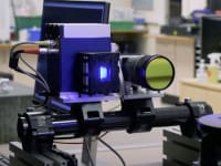
CubeSat-Compatible, High-Resolution, Thermal Infrared Imager
A small, adaptable, and stable thermal imaging system was developed that can be flown on an aircraft, deployed on the International Space Station as an attached payload, launched on a ride-share as an entirely self-contained 3U CubeSat, flown on a small satellite, or be a co-manifested...
Briefs: Imaging
Frequency combs derived from optical microresonators are required to reach an octave in span. This is required for self-referencing a comb. Presently, the frequency comb...

Briefs: Imaging
NASA Vision Workbench (VWB)
VWB is a modular, extensible computer vision framework that supports tasks including automated science and engineering analysis, large satellite image processing, and 2D/3D environment reconstruction. The framework provides a rapid C++ development environment as well as a flexible, multi-platform system to deploy...
Briefs: Imaging
Flight Proving a Heliophysics Soft X-Ray Imager
The interaction between the solar wind and the Earth’s magneto - sphere results in “space weather.” To determine the true nature of the solar wind-magnetosphere interaction, scientists require global measurements of processes occurring at the bow shock, in the magnetosheath, and at the...
Briefs: Imaging
Intensity Interferometry Image Recovery
This software extends the well-known error-reduction Gerchberg-Saxton method to imaging of dark objects, assuming that such an object partially shadows a well-characterized thermal light source, while the shadow cannot be used for inferring the object’s shape. These assumptions are reasonable for a wide...
Briefs: Imaging
Cameras for All-Sky Meteor Surveillance (CAMS) Version 1.3
The CAMS system comprises a deployment of multiple narrow-field, low-light video cameras that completely covers the sky in a mosaic pattern from 30° elevation and above. Two or three such camera batteries separated by many kilometers allow for large atmospheric volume coverage, high...
Briefs: Imaging
Normalized Cross Correlation FPGA Implementation
A safe and precise landing system for Mars will match features seen in descent imagery against a map constructed from orbital imagery. The spacecraft attitude and altitude are known, but lateral position is known only poorly. From attitude and altitude, one can generate a mapping (homography) that...
Briefs: Imaging
Advanced Rapid Imaging and Analysis for Monitoring Hazards (ARIA-MH)
Space-based geodetic measurement techniques such as Interferometric Synthetic Aperture Radar (InSAR) and Continuous Global Positioning System (CGPS) are now critical elements in the toolset for monitoring earthquake-generating faults, volcanic eruptions, landslides, glacial...
Briefs: Imaging
Next-Generation Integrated Camera (NIC)
Design and fabrication of a modern, compact, highly modular, and extreme-environment-capable replacement have been proposed for the Mars Exploration Rover (MER) camera. This next-generation camera is based on a CMOS (complementary metal-oxidesemiconductor) imager rather than a CCD (charge-coupled device)...
Briefs: Imaging
Homography Warp Image FPGA Implementation
A landing system for Mars matches features seen in descent imagery against a map constructed from orbital imagery. The spacecraft attitude and altitude are known, but lateral position is known only poorly. From attitude and altitude, one can generate a mapping (homography) that allows the descent image to...
Briefs: Imaging
Improved Hall Thrusters Fed by Solid Phase Propellant
Hall thrusters normally use Xe propellant, which is expensive and scarce in the solar system. The weight of Xe is such that typical Hall thrusters are limited in specific impulse to approximately 3,000 s. The objective of this program was to improve and demonstrate Mg Hall thruster systems. Mg...
Briefs: Software
NGDCS Linux Application for Imaging-Spectrometer Data Acquisition and Display
A simple method of controlling recording and display of imaging spectrometer data in (airborne) flight was needed. Existing commercial packages were overly complicated, and sometimes difficult to operate in a bouncing plane. The software also was required to keep up with...
Briefs: Sensors/Data Acquisition
DARPA’s Mind’s Eye Program aims to develop a smart camera surveillance system that can autonomously monitor a scene and report back human-readable text descriptions of...
Briefs: Imaging
Visualization of fMRI Network Data
Functional connections within the brain can be revealed through functional magnetic resonance imaging (fMRI), which shows simultaneous activations of blood flow in the brain during response tests. However, fMRI specialists currently do not have a tool for visualizing the complex data that comes from fMRI scans....
Briefs: Information Technology
Viewpoints Software for Visualization of Multivariate Data
Viewpoints software allows interactive visualization of multi-variate data using a variety of standard techniques. The software is built exclusively from high-performance, cross-platform, open-source, standards-compliant languages, libraries, and components. The techniques included are:
Briefs: Imaging
Algorithm for Estimating PRC Wavefront Errors from Shack-Hartmann Camera Images
Phase retrieval (PR) and Shack-Hartmann Sensor (SHS) are the two preferred methods of image-based wavefront sensing widely used in various optical testbeds, adaptive optical systems, and ground- and space-based telescopes. They are used to recover the phase information...
Briefs: Imaging
The Integrated Intelligent Flight Deck (IIFD) project, part of NASA’s Aviation Safety Program (AvSP), comprises a multi-disciplinary research effort to develop flight...

Briefs: Communications
Flight Imagery Recorder Locator (FIRLo) and High-Temperature Radome
LDSD (Low Density Supersonic Decelerator) is a Mars EDL (entry, descent, and landing) Technology Development Project that launches three test vehicles out of the Pacific Missile Range Facility in Kauai. On the test vehicle, most mission science data can be recorded safely on land;...
Briefs: Physical Sciences
Typically, the cost of a space observatory is driven by the size and mass of the primary aperture. Generally, a monolithic aperture is much heavier and complex...
Briefs: Imaging
Reducing Drift in Stereo Visual Odometry
Visual odometry (VO) refers to the estimation of vehicle motion using onboard cameras. A common mode of operation utilizes stereovision to tri angulate a set of image features, track these over time, and infer vehicle motion by computing the apparent point cloud motion with respect to the cameras. It has...
Briefs: Physical Sciences
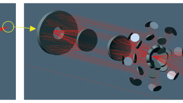
Technique for Finding Retro-Reflectors in Flash LIDAR Imagery
Orbital rendezvous and docking of two spacecraft is a topic of continued interest to NASA. For crewed missions, it is frequently the case that the target is cooperative (i.e., is equipped with some sort of navigation aid). If one of the relative navigation instruments is a Flash LIDAR,...
Briefs: Physical Sciences
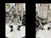
Novel Hemispherical Dynamic Camera for EVAs
A novel optical design for imaging systems is able to achieve an ultra-wide field of view (UW-FOV) of up to 208°. The design uses an integrated optical design (IOD). The UW-FOV optics design reduces the wasted pixels by 49% when compared against the baseline fisheye lens. The IOD approach results in a...
Briefs: Imaging
Reducing Drift in Stereo Visual Odometry
Visual odometry (VO) refers to the estimation of vehicle motion using onboard cameras. A common mode of operation utilizes stereovision to tri angulate a set of image features, track these over time, and infer vehicle motion by computing the apparent point cloud motion with respect to the cameras. It has...
Briefs: Imaging
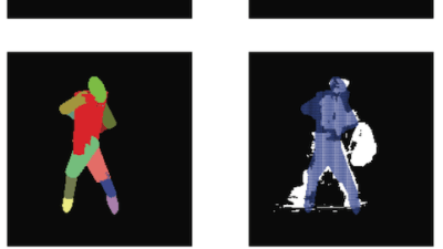
Resource-Constrained Application of Support Vector Machines to Imagery
Machine learning techniques have shown considerable promise for automating common visual inspection tasks. For example, Support Vector Machine (SVM) classifiers that have been learned from labeled training data deliver strong detection performance both for finding human faces in...
Briefs: Medical
Software for Non-Contact Measurement of an Individual’s Heart Rate Using a Common Camera
A software application detects the heart rate of an individual by using a real-time video stream from a common camera connected to their computer. This involves no contact between the user and the camera, or calibration between individual users. NASA’s...
Briefs: Physical Sciences
Planetary Data Systems (PDS) Imaging Node Atlas II
The Planetary Image Atlas (PIA) is a Rich Internet Application (RIA) that serves planetary imaging data to the science community and the general public. PIA also utilizes the USGS Unified Planetary Coordinate system (UPC) and the on-Mars map server.
Briefs: Physical Sciences
Automatic Calibration of an Airborne Imaging System to an Inertial Navigation Unit
This software automatically calibrates a camera or an imaging array to an inertial navigation system (INS) that is rigidly mounted to the array or imager. In effect, it recovers the coordinate frame transformation between the reference frame of the imager and the...
Briefs: Physical Sciences
Support Routines for In Situ Image Processing
This software consists of a set of application programs that support ground-based image processing for in situ missions. These programs represent a collection of utility routines that perform miscellaneous functions in the context of the ground data system. Each one fulfills some specific need as...
Briefs: Imaging
Wideband Single-Crystal Transducer for Bone Characterization
The microgravity conditions of space travel result in unique physiological demands on the human body. In particular, the absence of the continual mechanical stresses on the skeletal system that are present on Earth cause the bones to decalcify. Trabecular structure decreases in thickness...
Top Stories
 Blog: Lighting
A Stretchable OLED that Can Maintain Most of Its Luminescence
 Blog: Design
Batteries that Can Withstand the Cold
 INSIDER: Energy
Advancing All-Solid-State Batteries
 Quiz: Energy
 Blog: Data Acquisition
 Blog: Materials
Webcasts
 On-Demand Webinars: Test & Measurement
From Spreadsheets to Insights: Fast Data Analysis Without Complex Programming
 Upcoming Webinars: Aerospace
Cooling a New Generation of Aerospace and Defense Embedded...
 Upcoming Webinars: Test & Measurement
Beyond AI-Copy-Paste Engineering: Advanced AI-Integration Success...
 Upcoming Webinars: Energy
Battery Abuse Testing: Pushing to Failure
 Upcoming Webinars: Connectivity
A FREE Two-Day Event Dedicated to Connected Mobility
 Upcoming Webinars: Test & Measurement
Choosing the Right N-Port Strategy: Multiport VNAs vs. Switch...