-1
4020
30
Briefs: Manufacturing & Prototyping
Uniformly Etched Lateral Gratings Applied to Pre-existing Ridge Waveguides
There is great difficulty in implementing lateral gratings in GaSb-based lasers. Commercially, single-frequency GaSb lasers have been fabricated using metal gratings deposited laterally to the ridge-waveguide (RWG) stripe. The disadvantage of this is that the laser...
Briefs: Manufacturing & Prototyping
High-Precision Thin Film Metal Liftoff Technique
The objective of this work was to develop a thin film metal liftoff process that would allow one to accurately pattern two-micron-wide (or wider) features. The goal of this innovation was to pattern thin metal films on silicon substrates. The thin metal films can be deposited using physical vapor...
Briefs: Manufacturing & Prototyping
Process for 3D Printer Filament Fabrication
Conventional filament extrusion processes are unsuitable for recycling materials on the International Space Station due to requirements for continuous monitoring and tuning, as well as poor filament dimensional control. The Positrusion process recycles scrap or waste thermoplastics into filament for 3D...
Briefs: Communications
Confidence Intervals for the Bit Error Rate of Coded Communications Systems
The bit error rate (BER) is a wellunderstood metric for measuring communications system performance. When a system is not amenable to analytical performance analysis, a Monte Carlo simulation is often used to determine the performance. In such simulations, it is necessary...
Briefs: Communications
Final High-Fidelity Down-Conversion Source for Secure Communications Using On-Demand Single Photons
Secure communication over long distances requires robust encryption. While current encryption algorithms exist using classical methods, there are no unconditionally secure methods of distributing encryption keys classically. However, by exploiting...
Briefs: Communications
Space Telecommunications Radio System Memory Test Application
This software provides a portable, flexible memory testing application meeting the NASA Space Telecommunications Radio System (STRS) specification. As an STRS-compliant application, the tester application is portable to any STRS-compliant hardware/software platform. Thanks to...
Briefs: Communications
Functional Enhancements to the FPGA Implementation of the Advanced Orbiting System Data Link Protocol
Dynamic frame sizing was added to the existing AOS Packet Service FPGA implementation. This capability provides in-flight system calibration functionality, allowing the spacecraft and ground station the means to optimize a communication link by...
Briefs: Communications
Communication System and Method Over High-Latency, Low-Bandwidth Networks
In high-latency, low-bandwidth networks such as those employed when communicating with an extraterrestrial object via wireless communication over hundreds or thousands of miles, it may be difficult or expensive to communicate large quantities of information in a reliable...
Briefs: Communications
CASH: Framework for Streamlined, Daily Updates
Secure, efficient, and effective communication is critical for the multinational Cassini mission to Saturn. Cassini teams share information through the use of internal Web pages. The challenge was to develop dynamic Web pages that did not require special understanding of HTML complexities and the...
Briefs: Communications
SCaN Optical Link Budget Tool
In response to the requirements of the Space-Based Relay Study (SBRS) undertaken by NASA in 2013, as well as the Integrated Radio and Optical Communications (iROC) project being conducted by NASA Glenn Research Center (GRC) beginning in 2012, a calculation procedure was required to rapidly assess the operation of...
Briefs: Medical
Universal Cell-Directed Nanotheranostics
The present invention relates to the field of nanotechnology and, more particularly, to the field of delivery of active agents such as therapeutic and/or imaging agents using micro/nanoscale particles. Porous particles, such as porous silicon particles and porous silica particles, have a number of...
Briefs: Medical
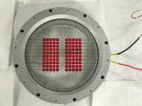
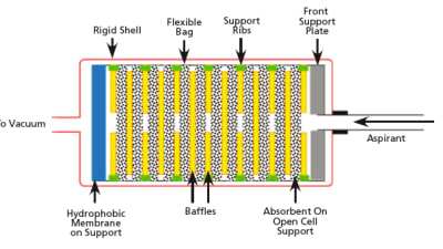
Fluid Preservation System (FPS)
Biological samples contain labile molecules that deteriorate rapidly ex-vivo. Terrestrially, biological samples are preserved either by freezing them (–80 °C) or by including preservation chemicals. While chemical preservation may be ideal for certain molecules, their functionality is selective and can, while...
Briefs: Medical
Using Electromagnetic Time-Variance Magnetic Fields to Generate and Re-Grow Cartilage
Adevice provides electromagnetic pulses at a predetermined frequency that will result in cartilage cell regeneration and regrowth for patients with arthritis, which reduces or eliminates joint cartilage. The device can be wrapped around the joints in a patient...
Briefs: Medical
Computer-Aided Design Tools to Support Human Factors Design Teams
The purpose of this work was to develop a database of human model behavior primitives, which are basic scripts that can be chained together to create simulations of humans performing certain tasks. This is unique in that the human model behaviors were collected using motion capture...
Briefs: Medical
NASA has long recognized the difficulty in providing emergency medical care to astronauts in space. Many aspects of space travel make medical care inherently difficult, and sufficient storage space...
Briefs: Medical
Use of Osteoclast-Inhibiting Compounds to Prevent Radiation-Induced Bone Loss
This technology features a method for preventing or treating radiation-associated loss of bone mass, bone density, or bone strength in a subject. This technology involves administering to the subject an amount of anti-resorptive or osteoclast-inhibiting compound...
Briefs: Information Technology
Automated Generation of Failure Modes and Effects Document from a Simple SysML Model
This software queries a model of system in the MagicDraw program and uses that information to create an Excel spreadsheet that represents a basic FMEA (Failure Modes and Effects Analysis). It automates the generation of an FMEA; the user only has to open MagicDraw,...
Briefs: Software
Space Network Access System (SNAS)
SNAS is a single, universally accessible, standards-based, full-featured customer interface for performing Tracking and Data Relay Satellite System (TDRSS) planning, scheduling, and real-time service monitoring and control. It consolidates functionality of multiple legacy customer interface systems into a single...
Briefs: Information Technology
Educational Software for OctaSat Nanosatellite Training Kit
Nanosatellites are very small satellites that can conduct various space missions using microelectronics, primarily in near-Earth orbits. Aerospace engineering students need to learn about the working principles and control of nanosatellites. However, the cost of an actual nanosatellite...
Briefs: Information Technology
NASA App
The NASA App showcases a huge collection of the latest NASA content in a mobile optimized format, including images, videos on-demand, NASA Television, mission information, news and feature stories, tweets, ISS sighting opportunities, satellite tracking, Third Rock Radio, featured educational content, and much more for iOS and Android...
Briefs: Electronics & Computers
Program to Categorize and Count Observations Performed by the Mars Reconnaissance Orbiter
CreateMEPReport.pl software is designed to read through a description of observations scheduled to be taken by the instruments onboard the Mars Reconnaissance Orbiter (MRO) spacecraft to categorize the observations, and then present totals for the categories...
Briefs: Software
Anomaly Detection in Large Sets of High-Dimensional Symbol Sequences (sequenceMiner)
SequenceMiner was developed to address the problem of detecting and describing anomalies in large sets of high-dimensional symbol sequences. sequenceMiner works by performing unsupervised clustering (grouping) of sequences using the normalized longest common...
Briefs: Information Technology
Time-Scaled Activity Diagram Simulator
The Time-Scaled Activity Diagram Simulator software simulates and animates time-tagged events as an overlay on activity and internal block diagrams in MagicDraw as a plugin application. “Events” are quite generic and include atomic actions, compound actions, signal and message exchanges, invocations, and...
Briefs: Information Technology
General-Use Nodal Network Solver (GUNNS)
Crewed space vehicle training has always required highfidelity models of vehicle systems. Many of these systems, particularly of the “flow” variety, benefit from modeling the system as a whole, rather than relying only on the interactions between individual components. In general, system properties...
Briefs: Software
Modularized SIR-to-NetCDF Conversion Command-Line Tool
This innovation reads in a proprietary formatted binary data format known as Scatterometer Image Reconstruction (SIR), and converts these data files to netCDF-classic format. This software is provided as a command-line tool for Linux/UNIX-based systems, and includes built-in regression testing...
Briefs: Imaging
Stereoscopic Planar Laser-Induced Fluorescence Imaging for Time-Resolved 3D Movies in Hypersonic Flow
Understanding and predicting transition from laminar to turbulent flow in hypersonic boundary layers is an active and important field of research because transitional and turbulent heating can be four or more times higher than laminar heating on...
Briefs: Imaging
Modified-Wolter-Schwarzschild X-ray Telescope
X-ray survey missions require nested grazing incidence telescopes with a large field of view (1° or larger) and moderately high resolution across the field of view. This cannot be accomplished using flat focal plane detectors. The telescopes have excellent on-axis resolution, but unacceptable...
Briefs: Imaging
Machine Vision-Based Pose Estimation System
During on-orbit servicing of non-cooperative satellites, the relative position of the satellite with respect to the servicing vehicle is needed. Non-cooperative satellites do not have devices to assist the pose estimation (such as markers or reflector), so a system that uses the natural features of the...
Briefs: Imaging
Solar Doppler Shift-Based Solar Tracker
This solar tracker integrates a camera with a field of view (FOV) large enough to easily image the entire solar disc — co-boresited with a narrow-band spectrometer that measures the frequency of a Doppler shifted line — with an algorithm designed to drive zero Doppler shift rotation axis of the Sun.
Top Stories
 Blog: Design
A Stretchable OLED that Can Maintain Most of Its Luminescence
 INSIDER: Energy
Advancing All-Solid-State Batteries
 Blog: Power
My Opinion: We Need More Power Soon — Is Nuclear the Answer?
 Blog: Energy
Batteries that Can Withstand the Cold
 Quiz: Power
 Blog: Communications
Microscopic Swimming Machines that Can Sense, Respond to Surroundings
Webcasts
 On-Demand Webinars: Semiconductors & ICs
Advantages of Smart Power Distribution Unit Design for Automotive &...
 Upcoming Webinars: Transportation
Quiet, Please: NVH Improvement Opportunities in the Early Design...
 Upcoming Webinars: Sensors/Data Acquisition
From Spreadsheets to Insights: Fast Data Analysis Without Complex...
 Upcoming Webinars: Aerospace
Cooling a New Generation of Aerospace and Defense Embedded...
 Upcoming Webinars: Test & Measurement
Beyond AI-Copy-Paste Engineering: Advanced AI-Integration Success...